Indonesia/Maldives forecast Oct 8
Indian Ocean Basin analysis by Craig Brokensha (issued Tuesday 8th October)
This week through next (Oct 9 - 18)
Our large S’ly groundswell for the weekend was just that with pumping surf across most locations and consistent, solid surf through Saturday.
The energy has since started to ease though a reinforcing pulse of mid-period S/SW energy should be in the water today.

This swell will be backed up by a slightly stronger but less consistent SW groundswell into this afternoon and tomorrow morning, then easing into the afternoon, further Thursday.
We then look towards our SW groundswell due into Friday/Saturday, with some secondary reinforcing S/SW energy on Sunday.
This has been generated by a healthy frontal progression moving through the southern Indian Ocean the last few days, with the tail of it now south-west of Western Australia.
The initial stages have generated various fetches of gales, with a large SW groundswell due to build through Friday, with the peak in size extending from the afternoon/evening into Saturday morning.

The current activity off Western Australia should produce some smaller, reinforcing S/SW swell for later Saturday and more so Sunday morning. We’ll then see the swell tail away into the start of next week.
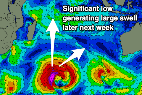
Into the end of next week though we’re looking at a large, long-period SW groundswell for all of Indonesia (coming in more S/SW to the west). This will be thanks to a significant low pressure system firing up to the south-east of South Africa tomorrow evening, generating a slow moving fetch of severe-gale to storm-force W/SW tending SW winds.
The swell from this low should come in around a similar if not slightly larger size compared to Saturday’s (just gone) swell but with more west in it. We’ll confirm this in Thursday’s update.
----------------------------------------------
Maldives: We’re looking at easing levels of S/SE trade-swell across the region, but a growing fetch of E/SE trades south-west of Sumatra should bring building levels of moderate + sized SE trade-swell later week (from Friday), persisting through the weekend and possibly most of next week.
The longevity will depend on the deepening of a tropical depression south of us, possibly strengthening the trade-swell further early next week. We’ll review this on Thursday.
This will also bring very strong westerly winds across the region feeding into the tropical depression from today/tomorrow, making for tricky conditions over the coming week.
Otherwise, a large S/SW groundswell should override the south-east energy across the southern atolls from later tomorrow but more so Thursday, generated by a strong frontal progression firing up under South Africa on the weekend.
This swell is due to ease slowly Friday ahead of the next pulse of large S’ly groundswell energy into Tuesday afternoon/Wednesday next week. This looks larger and longer in period, generated by the severe low forming south-east of South Africa later this week.
More on this Thursday.
Eastern Indonesia:
Inconsistent mix of background SW groundswell and mid-period S/SW swell energy Tuesday/Wednesday to 4-5ft+.
Large sized SW groundswell building Friday, reaching 6-8ft into the afternoon, holding Saturday morning.
Less consistent, reinforcing S/SW groundswell for later Saturday/Sunday morning to 6ft to possibly 8ft across exposed breaks, easing.
Large SW groundswell building next Wednesday afternoon, peaking Thursday to 10ft across exposed breaks.
Weak E/SE-SE trades, variable offshore winds each morning. Winds tending lighter S/SE-S next week.
Uluwatu 16-day Forecast Graph/WAMs
Western Indonesia/Mentawais/South Sumatra:
Small-mod sized, inconsistent SW groundswell for Tuesday afternoon/Wednesday morning to 4-5ft+.
Large sized S/SW groundswell building later Thursday, peaking Friday afternoon to 6ft to occasionally 8ft, easing from a slightly smaller size Saturday, further into Sunday.
Large, powerful S/SW groundswell building Wednesday next week, reaching 8-10ft across exposed breaks, easing slowly Thursday.
Mod-fresh S/SE-SE winds today and tomorrow (lighter to the north), variable across all locations from Thursday, tending light NW across northern locations from the weekend.
Mentawai 16-day Forecast Graph/WAMs
Maldives:
Fading S/SE trade-swell over the coming days (bottoming out around 2ft+).
Large S’ly groundswell building later tomorrow, peaking Thursday to 6ft+ across the southern atolls, easing slowly Friday.
Moderate sized SE trade-swell building Friday, reaching 4-5ft through the weekend, likely holding early next week.
Large S’ly groundswell building Tuesday afternoon, peaking Wednesday morning to 6-8ft across the southern atolls (smaller Male)
Very strong W’ly winds developing from today, persisting all week and then slowly abating on the weekend but still remaining gusty.


Comments
Latest notes are live.
Thanks Craig , this year just keeps giving.