Indonesia/Maldives forecast Sep 26
Indian Ocean Basin analysis by Craig Brokensha (issued Thursday 26th September)
This week through next (Sep 27 - Oct 4)
Fun levels of swell have persisted across the exposed breaks the last two days, with a mix of long-range inconsistent SW groundswell and mid-period S/SW swell due to fill in today and hold tomorrow morning.
The swell should then ease into Saturday ahead of our inconsistent pulses of SW groundswell from Sunday afternoon through Tuesday.
There’s been no change to the expected size from these sources, with the swell traveling through the Indian Ocean.
The first swell looks moderate + in size but inconsistent, with the peak in energy persisting from Sunday afternoon through Tuesday morning, while a slightly stronger but super inconsistent reinforcing SW groundswell is due later Wednesday but more so Thursday.
This should provide a bit more size on those magnets before easing Friday.

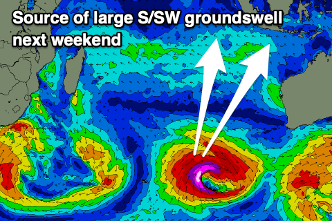
We then look at the more significant low that’s due to spawn north-east of the Heard Island region early next week, with a great fetch of severe-gale to storm-force S/SW winds due to project up towards Indonesia as the system moves slowly east.
A large, long-period S/SW groundswell is expected from this source, arriving Friday afternoon, peaking Saturday to 8-10ft across exposed breaks.
Following this storm, another strong but more zonal storm looks to generate a reinforcing S/SW groundswell for Monday, likely more to 8ft or so. We’ll have a closer look at this on Tuesday.
----------------------------------------------
Maldives: A steady supply of S/SE-SE trade-swell is keeping exposed breaks active this week, and a re-strengthening and eastward expansion of SE trades over the coming days should bring a renewal of energy later in the weekend and more so next week.
With this a low point in energy is likely Saturday and Sunday morning before building again.
Across the southern atolls, various pulses of strong, large S’ly groundswell are due, with the first building tomorrow afternoon, peaking Saturday before easing slowly Sunday.
A secondary, similar sized pulse of groundswell from polar activity south and south-east of South Africa should later Monday but peak through Tuesday.
The strong low forming north-east of the Heard Island region is a bit far east of our swell window but it’s north projection should still send some S/SE groundswell our way, most likely next weekend. More on this next update.
Eastern Indonesia:
Small-moderate sized reinforcing swells for today/tomorrow.
Moderate sized, inconsistent SW groundswell building Sunday afternoon reaching 5ft and holding Monday before easing slowly Tuesday. Possible rare bigger one at times.
Moderate + sized, inconsistent SW groundswell arriving Wednesday, building towards 6ft across exposed breaks later, holding a similar size Thursday.
Larger S/SW groundswell building later Friday, peaking Saturday to 8-10ft across exposed breaks.
Large, reinforcing S/SW groundswell likely Monday the 7th.
Weak E/SE-SE trades freshening a little over the weekend and early next week. Variable offshore winds each morning.
Uluwatu 16-day Forecast Graph/WAMs
Western Indonesia/Mentawais/South Sumatra:
Small-moderate sized SW groundswell easing today.
Moderate sized, inconsistent SW groundswell building Sunday, reaching 5ft+ across exposed breaks, easing from a similar size Monday.
Moderate + sized inconsistent S/SW groundswell building later Tuesday, peaking Wednesday to 6ft across exposed breaks, easing slowly Thursday.
Larger S/SW groundswell for later Friday, peaking Saturday to 6-8ft across exposed breaks.
Gusty S/SE-SE winds kicking in from tomorrow and the weekend across southern locations, lighter to the north.
Winds tending variable from Tuesday.
Mentawai 16-day Forecast Graph/WAMs
Maldives:
Low point in S/SE-SE trade-swell Saturday/Sunday morning to 3-4ft across exposed breaks.
Building S/SE tending SE trade-swel from Sunday afternoon, holding most of next week to 4-5ft across exposed breaks.
Larger S’ly groundswell building tomorrow, peaking Saturday with 6ft sets across the southern atolls (smaller Male), easing Sunday.
Secondary similar sized S’ly groundswell arriving later Monday, peaking Tuesday, easing slowly Wednesday.
Moderate size S/SE groundswell likely next weekend.
Strong W/NW winds easing slowly tomorrow, still fresh NW on Saturday but lighter N/NW on Sunday.
Winds tending variable through Monday, possibly freshening a little from the S/SE-SW mid-late week.


Comments
Latest notes are live.
Geez the Maldives has been having an amazing run the last month. What a forecast.
Can't say the same about Indo. Been pretty mid this trip.
Very interesting Craig, if you could delay "Following this storm, another strong but more zonal storm looks to generate a reinforcing S/SW groundswell for Monday, likely more to 8ft or so." by a day or so that would be great!
Sounds like a good forecast period, but I'm definitely looking forward to Tuesday's update and early indicators as to what happens after Monday 7th. :)
Some double overhead sets ( unfortunately not many waves in a set 2-3 max ) today and the occasional 1 wave rogue that would clean up everyone , a lot more grunt in the power of the waves . Not consistent however . Biggest day here yet by far since arriving on 14th .
Wow. Wouldn't have expected that!
Surfed west of the main wave today Supa, 5ft right odd barrel, plenty of juice. Didn’t even make it out the front today.
Edit:4- 5 foot being 6-7’faces on the sets
Lucky bonus for you SF :)
Not the best shots but poor bloke had to walk a klm out onto the reef . This was the 1ft + day on 26th I think. It’s the + that makes the difference .


Nice! About the same size I surfed on that 1 ft day but I was going right.
Nice - that looks fun.