Indonesia/Maldives forecast Sep 24
Indian Ocean Basin analysis by Craig Brokensha (issued Tuesday 24th September)
This week through next (Sep 24 - Oct 4)
Monday’s pulse of moderate + sized S/SW groundswell came in good around the grounds, with it on the slow decline through today.
We’ll see this swell bottoming out into tomorrow, with some smaller, background SW groundswell and mid-period S/SW energy due to fill in Thursday, peak Friday and then ease slowly Saturday.
It’ll be inconsistent and the models are mixing the energy a bit so expect surf mostly to 4ft across the exposed breaks, slightly bigger in the Ments.
We then look at the increased activity that was touched on in last week’s forecast.

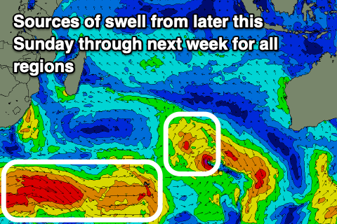
Unfortunately it’s gone the way of EC, the European forecasting centre, with the frontal activity through the Southern Ocean being mostly disjointed and not overly consolidated.
With this we’re looking at inconsistent, moderate sized pulses of distant SW groundswell into Sunday/Monday with some secondary long-range pulses for early in the new month.
Most of this energy will be generated in our far swell window to the south and south-east of South Africa, with the pulse for Sunday/Monday already being produced.
Size wise, each swell at this stage doesn’t look to to top 5ft from Sunday afternoon through Tuesday morning, with the secondary long-period swell for Wednesday afternoon/Thursday morning looking a bit better and to 6ft on the sets but slow.
Following this a stronger storm may fire up in the southern Indian Ocean earlier next week, generating some larger S/SW groundswell for Saturday the 5th, more on this next update.
For the Mentawai region the size looks similar thanks to the origin of each swell producer.
----------------------------------------------
Maldives: This week we’ve got various ebbs and pulses of S/SE-SE trade-swell in the 3-5ft range across the magnets, with a renewal of strong SE trades to our south mid-late week due to kick up some more energy into the weekend and early next week.
We’ve also got plenty of S’ly groundswell generated by the activity to the south of South Africa with the first pulse due today, followed by the next increase Friday afternoon and on the weekend.
These pulses look stronger than today’s with sets to 6ft across the southern atolls, easing a little Sunday and then followed by another strong, similar sized increase next Tuesday/Wednesday.
Further pulses of healthy S’ly groundswell are then due later next week onwards, but more on this Thursday.
Eastern Indonesia:
Fading surf tomorrow.
Small-moderate sized reinforcing swells for Thursday/Friday.
Moderate sized, inconsistent SW groundswell building Sunday afternoon reaching 5ft and holding Monday before easing slowly Tuesday.
Moderate + sized, inconsistent SW groundswell arriving Wednesday, building towards 6ft across exposed breaks, easing from a similar size Thursday.
Larger S/SW groundswell likely Saturday the 5th.
Weak S/SE-SE trades over the coming week, variable offshore each morning. Weak E/SE-SE trades kicking back in from late next week.
Uluwatu 16-day Forecast Graph/WAMs
Western Indonesia/Mentawais/South Sumatra:
Small, inconsistent SW groundswell building tomorrow to 4-5ft, easing Thursday from a similar size across exposed breaks.
Moderate sized, inconsistent SW groundswell building Sunday, reaching 5ft+ across exposed breaks, easing from a similar size Monday.
Moderate + sized inconsistent S/SW groundswell building later Tuesday, peaking Wednesday to 6ft across exposed breaks, easing slowly Thursday.
Larger S/SW groundswell likely Friday/Saturday the 4/5th.
Weak SE winds across southern locations this week, variable to the north. Fresher SE winds kicking in from the weekend across southern locations, lighter to the north.
Mentawai 16-day Forecast Graph/WAMs
Maldives:
Ebbs and pulses of S/SE-SE trade-swell to 3-5ft all week and weekend.
Moderate sized S’ly groundswell peaking today to 3-5ft across the southern atolls (smaller Male).
Larger S’ly groundswell building Friday, holding Saturday with 6ft sets across the southern atolls (smaller Male).
Secondary similar sized S’ly groundswell next Tuesday/Wednesday.
Strong W-W/NW winds across northern and central locations over the coming days, weaker to the south.
Winds easing from Friday across all locations, weaker NW-N/NW on the weekend, variable to the south.
Moderate W-W/SW winds across all locations into next week.


Comments
Latest notes are live.
Thanks Craig , we arrive at our next destination on the 3rd so we may be in for some action .
Hi Craig, is it too early to gaze into that Crystal ball of yours as to what the forecast may look like after the 5th - is there still a chance of moderate-large pulses (as per previous notes), or is the 4/5th the moderate to large pulse/s and it looks to slow up after the 4/5th?
We're in the Banyaks as of the 8th and hoping the Indian Ocean doesn't take another break after these forecast swells....?
Yeah a bit far out but we could see some action in the southern swell window, south-west of Western Australia.
thanks Craig - that should be enough to get me through to next Thursday's and Tuesday's notes.
Geez I hope this 1ft+ keeps up, the last 3 days is the best 1-2ft I’ve seen . It’s the + that makes the difference .
Was bigger than. 3 ft where I surfed today.
Am cooked.
Plenty of places over there do very well, and are very fun, on a long period swell breaking at 3ft. How's the crowd factor Andy?