Indonesia/Maldives forecast Sep 12

Indian Ocean Basin analysis by Craig Brokensha (issued Thursday 12th September)
This week through next (Sep 13 - 20)
Our reinforcing pulse of S’ly swell expected yesterday afternoon and this morning across eastern locations didn’t really make an impact unfortunately with small surf seen across most spots.
We’ll see the size remaining minimal tomorrow and into the start of the weekend ahead of our new pulse of moderate + sized S/SW groundswell Sunday afternoon.
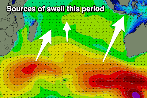
The healthy low generating the swell has since moved east, under Western Australia and out of our swell window.
It’ll be inconsistent but a fun size, with it due to build Sunday afternoon ahead of a peak early Monday, easing slowly into the afternoon and further Tuesday. The longevity of the swell will be extended thanks to the drawn out nature of the swell producing storm.
Make the most of this swell pulse as it looks slower through the rest of the week with no major swell sources due.
A small, inconsistent mid-period SW swell is expected on Thursday, produced by a distant, weak frontal system currently to the south-east of South Africa.
No major size is due but the direction is favourable.
Otherwise we’re looking at small, inconsistent S/SW groundswell energy into next weekend and beyond thanks to a strong Southern Ocean frontal progression firing up to the south-west of Western Australia. More on this Tuesday.
----------------------------------------------
Moderate + levels of SE trade-swell have been hanging in all week but we’ll see the energy starting to ease from tomorrow but more noticeably into the weekend. This is thanks to weakening of the swell generating trade-fetch strengthening across the northern Indian Ocean.
As the same time, a good pulse of moderate sized S’ly groundswell is due across the southern atolls later Saturday, peaking through Sunday. This was generated from the earlier stages of the strong low mentioned above in the Indonesian section.
The easing trend from this swell will be slow, thanks to a reinforcing mid-period S/SW swell generated by the system currently south-east of Madagascar.
The size looks to be a touch under Sunday’s and more south in nature.
We then look at the building S/SE trade-swell into the end of the week thanks to a restrengthening of the trade-fetch south of us early next week. Overall, at this early stage the size looks a touch under and more south of what we’re currently experiencing, but more on this Tuesday.
Eastern Indonesia:
Small surf over the coming days.
Moderate + sized mid-period S/SW swell building Sunday afternoon, with magnets reaching 6ft on the sets later, easing slowly from a similar size Monday morning. Reinforcing smaller S/SW swell Tuesday, slowing the easing trend.
Small, inconsistent mid-period SW swell for later Thursday and Friday morning to 4ft across exposed breaks.
Weak S/SE-SE trades over the coming period (S-S/SW next week), variable offshore each morning.
Uluwatu 16-day Forecast Graph/WAMs
Western Indonesia/Mentawais/South Sumatra:
Small surf over the coming days.
Moderate + sized S/SW groundswell building Sunday afternoon to 4-6ft, peaking Monday morning to 5-6ft, easing thereafter.
Small to moderate sized mid-period SW swell building Wednesday afternoon, peaking Thursday to 3-5ft.
Light to moderate E/SE-SE winds across southern locations tomorrow, variable to the north.
Freshening S/SE-SE winds over the weekend, weaker to the north, holding early-mid next week.
Winds slowly easing from Thursday.
Mentawai 16-day Forecast Graph/WAMs
Maldives:
Slowly easing SE swell tomorrow from the 4ft+ range, further through the weekend and early next week.
Moderate sized S’ly swell building later Saturday, peaking Sunday to 3-5ft across the southern atolls, smaller elsewhere.
Easing swell Monday with a reinforcing S/SW swell Tuesday to 3-4ft across the southern atolls.
Moderate sized S/SE trade-swell building Friday next week, further next weekend to 3-5ft across exposed breaks (smaller Male).
Light to moderate W winds across northern and central locations tomorrow, variable across southern locations.
Slight freshening in winds Saturday across northern and central locations, extending to the south Sunday.
Slowly strengthening W/NW-W winds next week across northern and southern locations, weaker to the south.
Comments
Latest notes are live.
Thanks Craig. Can you please order another run of swells coming to finish off the season?
Yes please order a couple solid swells for first 2 weeks of Oct. :)
If that cannot be done, please ensure its not the devil southerly wind at least!
Reports from ments last few days? Sun/ Mon swell bit undersize North Sumatra islands