Indonesia/Maldives forecast Sep 3
Indian Ocean Basin analysis by Craig Brokensha (issued Tuesday 3rd September)
This week through next (Sep 4 - 12)
A mix of moderate sized S/SW and S groundswells for yesterday are now on the ease with our new pulse of inconsistent, S/SW groundswell for tomorrow afternoon/evening on track, peaking overnight and easing Thursday.
As touched on last update, the models are incorrectly combining swells on the forecast chart and over-forecasting size. While storm-force winds were produced, they were relatively short-lived and at distance to us, with the swell due to come in at the moderate-large size range.

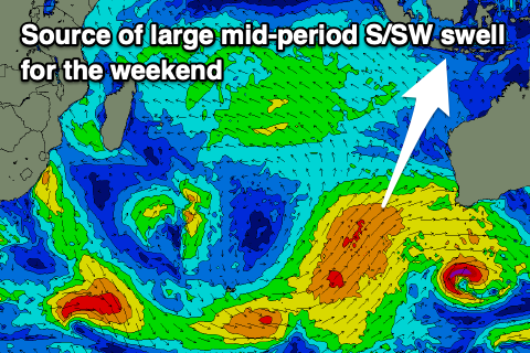
A reinforcing S/SW groundswell for Friday looks similar with the models again incorrectly combining swells. The source of this swell Friday was a small, tight low forming west-southwest of Western Australia. It looks to come in under tomorrow/Thursday’s energy, with some better mid-period S/SW swell due on the weekend.
The mid-period swell is currently being generated by a broad but relatively weak frontal system projecting towards Western Australia, with a fetch of strong, but below gale-force SW-S/SW winds due to project up towards us over the coming days.
This should generate a large, consistent mid-period S/SW swell for the weekend, building later Saturday and peaking Sunday morning.
Following this the outlook is slower for next week with things winding down across the Souther Ocean. Therefore make the most of the coming swells.
----------------------------------------------
Over in the Maldives, the large pulse of S/SE trade-swell seen over the weekend and yesterday came in a little above expectations in a few spots, with large 6-8ft sets reported, over the expected 5-6ft.
This energy was generated by a super-charged fetch of E/SE-SE trades that setup to our south late last week, with it since weakening while starting to migrate east.
This will result in easing levels of S/SE tending SE trade-swell tomorrow and Wednesday, with the next episode of SE swell due to start building back in size from Friday.

A restrengthening and expansion of the SE trade-flow should generate building levels of swell that should reach moderate + in size from Friday afternoon through the weekend, persisting into early next week before starting to ease a little from Tuesday/Wednesday.
Southerly groundswell wise, there’s not much to talk about, but the SE trade-swell will provide plenty of action.
Local winds are still shifting a bit but it looks like the northern and central locations will see persistent, moderate to at times fresh W-W/NW winds this period (weaker on the weekend), likely strengthening from the W-W/SW during next week at some stage.
The southern atolls look more variable, taking a S’ly tendency into next week. More on this Thursday.
Eastern Indonesia:.
Mod-large S/SW groundswell building Wednesday, reaching 6ft to possibly 8ft across exposed breaks later, easing Thursday from a slightly smaller size.
Smaller, reinforcing S/SW groundswell late week to 6ft.
Large, mid-period S/SW swell building later Saturday, peaking Sunday morning to 8ft across exposed breaks, slowly easing into next week with smaller, reinforcing pulses.
Moderate to fresh E/SE-SE trades, lighter and more variable each morning. Stronger trades kicking in from late week, persisting Saturday/Sunday.
Uluwatu 16-day Forecast Graph/WAMs
Western Indonesia/Mentawais/South Sumatra:
Moderate + sized S/SW groundswell for later Wednesday and Thursday morning to 4-6ft across exposed breaks.
Inconsistent S/SW groundswell Friday to 4-6ft across the exposed breaks.
Moderate sized mid-period S’ly swell through this week and weekend.
Moderate + sized mid-period S’ly swell for Sunday to 6ft across exposed breaks, easing next week.
Strong S/SE-SE trades over the coming days, weakening slowly across northern locations during the weekend and next week.
Mentawai 16-day Forecast Graph/WAMs
Maldives:
Slowly easing SE trade-swell over the coming days.
Building SE trade-swell Friday, peaking from Saturday through Monday to 4-5ft+ across exposed locations (smaller Male).
Slowly easing trade-swell from Tuesday next week.
Moderate to at times fresh W-W/NW across northern/central locations (weaker on the weekend), likely strengthening from the W-W/SW during next week at some stage.
More variable winds across the southern atolls, taking a S’ly tendency into next week.


Comments
Latest notes are live.
Please excuse my ignorance but what is the favourable wind direction for the southern atolls?
From what I can gather, next week is looking promising swell-wise (not flat) but which direction is offshore?
Zen the southern atolls has breaks on every part of the atoll apart from the north facing. So if your captain is prepared to travel you have offshore winds pretty much on one side (or bottom) of the southern atoll whichever way the wind is blowing.
But most of the time you’re surfing either East to SE facing or South facing breaks.
Stoked Don, thanks for your knowledge on this.
We pretty much had an exchange about this years ago. So stoked we can revisit it.
Any visibility on the longer term (beyond next week)? Trying to decide where to head on a surf trip!
At this early stage, slower and smaller.
Still fun? Or are we talking pretty flat...?
Depends where, some places will likely go flat with small surf on the magnets,
Thanks Craig. Fingers crossed some swell pops up otherwise might have to go diving somewhere instead!
You can definitely rule out rote , think I will be just sailing and fishing down there, long range looks 2ft .