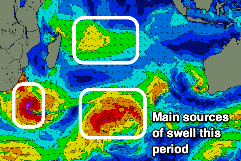
Indonesia/Maldives forecast Aug 22
Indian Ocean Basin analysis by Craig Brokensha (issued Thursday 22nd August)
This week through next (Aug 23 - 30)
We should be seeing an inconsistent, long-range SW groundswell building across the region today with it generated in our far swell window to the south-east of South Africa.
A peak is due into this afternoon, with it easing back through tomorrow and further on the weekend.
We then look to our large S/SW groundswell due into early next week, with the low linked to it traversing under South Africa before now intensifying in the Indian Ocean tracking east-northeast towards Western Australia.
A fetch of gale to severe-gale W/SW-SW winds will be generated through Indonesia’s south-west and then southerly swell windows today and tomorrow, with the storm weakening on approach to Western Australia, the majority of the swell generating will be done.

A large, fairly consistent S/SW groundswell will result with it due to fill in Tuesday, peaking through the day.
A drop in size is due later, with the swell easing through Wednesday and Thursday.
Into Friday, a very inconsistent, long-range SW groundswell is due, generated by an off axis and poorly aligned (for Indonesia) but strong low spawning off South Africa.
No real size is due with moderate sized sets on the cards for Friday afternoon and Saturday.
We’re then looking at a slower period of surf into the start of September with the frontal activity firing up more towards Australia, away from our prime swell windows. More on this Tuesday.
----------------------------------------------
Over in the Maldives, a mix of easing S’ly groundswell and SE trade-swell will build back through tomorrow out of the S/SE.
This S/SE trade-swell now looks to peak through tomorrow and the weekend before slowly tailing off into next week owing to the fetch of swell generating E/SE-SE to our south weakening from tomorrow and then shifting more east, towards Sumatra.
This will also see the swell direction tweak more SE through next week but with easing size and period.
At the same time, we’ve got our moderate sized S’ly groundswell due, generated by the strong storm moving from under South Africa. We should see this swell arriving through Monday afternoon, peaking Tuesday morning.
Of greater significance though is a larger S’ly groundswell pulse due later Tuesday and into Wednesday morning, generated by the off axis low moving from under Madagascar which isn’t too favourable for Indonesia will be great for the Maldives. A fetch of severe-gale to storm-force S-S/SE winds due to generate a large groundswell with plenty of sizey, mid-period energy to follow later week.
We’ll also see the remnants of this low then feed into a redeveloping trade-fetch south of us through next week, generating moderate levels of S/SE trade-swell from later week and beyond.
Eastern Indonesia:
Large, inconsistent SW groundswell later this afternoon and tomorrow morning to 8ft across exposed breaks on the sets.
Large S/SW groundswell building on dark Monday, peaking Tuesday to 10ft across exposed breaks, easing thereafter.
Small-moderate sized, inconsistent SW groundswell for next Friday building to 3-5ft.
Moderate to fresh E/SE-SE trades this week, light and variable tending locally offshore every morning. Lighter S/SE-SE winds next week.
Uluwatu 16-day Forecast Graph/WAMs
Western Indonesia/Mentawais/South Sumatra:
Large inconsistent SW groundswell peaking today to 8ft across exposed breaks, easing tomorrow and further into the weekend.
Large S/SW groundswell building Monday afternoon, peaking Tuesday morning to 8-10ft across exposed breaks, easing the rest of the week.
Inconsistent, moderate + sized SW groundswell Thursday to 5-6ft across exposed breaks.
Moderate to fresh S/SE-SE trades across southern locations today and tomorrow, variable to the north. Trades strengthening and spreading north on the weekend, easing into next week.
Mentawai 16-day Forecast Graph/WAMs
Maldives:
Moderate sized S/SE trade-swell building today and tomorrow, peaking through the weekend to 4-5ft across exposed breaks, easing slowly next week.
Smaller SE trade-swell for next week.
Moderate sized S’ly groundswell for later Monday and Tuesday morning to 4ft across the southern atolls.
Larger S’ly groundswell for later Tuesday and Wednesday morning to 6-8ft across the southern atolls.
Weaker N-NE winds across northern and central locations tomorrow, E/NE to the south with variable winds Saturday, tending W/NW on Sunday (W/SW across southern locations).
Moderate W/SW-SW winds next week, weaker S to the south.


Comments
Latest notes are live.
Noooooooo
“We’re then looking at a slower period of surf into the start of September with the frontal activity firing up more towards Australia, away from our prime swell windows. “
@goofyfooter , what dates for GLand ? It looks pretty good to me if that forecast holds , is 6-8 ft gland not what you’re looking for ? Bigger maybe 10-12 ? Keep the faith mate you’re going to get barreled off ya nut .
I’ve got mates there at the moment. It’s been firing.
I’ll be happy with that supa ha ha.
4th until the 13th I think it is.
How is it where you are?
It’s good down here, but only get to surf in the morning before trades blow it out , crowds about 20 people, mainly euros . Indonesia certainly is attracting tourists from all over the world in large numbers, my mate that is showing me around has only ever seen about 6 people max at this spot before .
Can you name what island?? Or top secret?
@goofyfoot , I’d rather not say . Anyway if you’re arriving gland on the 4th and this report holds , then hang on to ya hat ! Think I’ve mentioned before , that there is always a pumping swell first week of September .
Hey Craig,
Should I expect the banyaks to be similar to the nias forecast?
Stinging for the weekend and next weeks forecast