Indonesia/Maldives forecast Jul 30
Indian Ocean Basin analysis by Craig Brokensha (issued Tuesday 30th July)
This week through next (Jul 31 - Aug 9)
The surf is small today, but a good pulse of new SW groundswell is due tomorrow ahead of a larger S/SW groundswell Thursday.

There’s been no change to the expected size of tomorrow’s swell, with Thursday’s coming in a little earlier and peaking into the afternoon.
It’s come in on forecast in Western Australia with extra-large sized surf seen this afternoon and we should see it building Thursday, biggest later in the day and then easing Friday.
Looking at the weekend, and a trailing, weaker frontal system on the back of the significant swell generating storm for this Thursday should generate a reinforcing swell later Saturday and more so Sunday morning, but it’ll be lower period and not as strong as Thursday’s energy, easing through early next week.
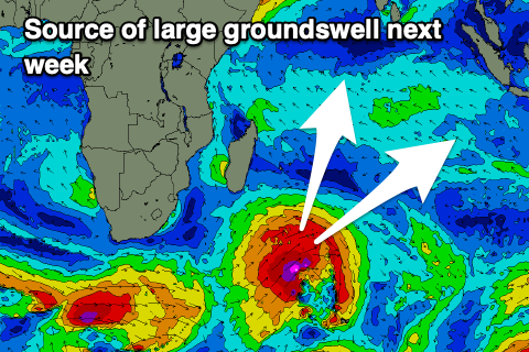
We then look to a couple of strong lows spawning off South Africa, with them tracking nicely through Indonesia’s south-western swell window.

An initial low looks to generate a great fetch of gale to severe-gale-force winds, weakening once reaching the mid-Indian Ocean, with a large, long-period SW groundswell to result.
This swell should build Wednesday and be strongest on dark and into Thursday morning (peaking Wednesday across the Ments).
Following this, further activity may generate some larger, reinforcing SW groundswell energy for the following weekend but we’ll have a closer look at this on Thursday.
----------------------------------------------
The SE trade-swell pulsed into Saturday again before easing through Sunday and further into the start of the week.
A relaxation of swell producing trades will see the swell continuing to ease into the end of the week before starting to ramp up again into Friday and the weekend.
This will be thanks to a restrengthening of the trades to our south-east over the coming days, though weakening into the weekend again resulting in easing size through next week.
Looking at the S/SE groundswell from the strong cold outbreak in the south-east Indian Ocean and we should see this building Friday, peaking into the afternoon and then easing Saturday.
Of greater significance is a larger S’ly groundswell generated by the strong low spawning off South Africa, with it die to fill in Monday afternoon/Tuesday morning, coming in with quite a bit of size across the southern atolls.
Another pulse is likely later in the week but check back here on Thursday for the latest.
Eastern Indonesia:
Moderate sized SW groundswell tomorrow to 4-5ft+.
Large S/SW groundswell building strongly Thursday, reaching 10ft later across exposed breaks, easing Friday.
Reinforcing mod-large, mid-period S/SW swell for later Saturday and early Sunday to 6ft+, easing into early next week.
Large, long-period SW groundswell building Wednesday, reaching 8ft by dark, similar Thursday morning.
Moderate to fresh E/SE-SE trades (weaker later week), with variable winds each morning.
Uluwatu 16-day Forecast Graph/WAMs
Western Indonesia/Mentawais/South Sumatra:
Moderate sized SW groundswell later today and tomorrow morning to 4-5ft+.
Large S/SW groundswell for Thursday morning to 8ft across exposed breaks, easing into the afternoon and further Saturday.
Reinforcing S’ly swell for later Saturday and Sunday morning to 4-6ft.
Large SW groundswell for Wednesday to 8ft+, easing later in the week.
Fresh to strong S/SE-SE winds across southern locations most of the period, lighter across northern locations, especially late week onwards.
Mentawai 16-day Forecast Graph/WAMs
Maldives:
Easing SE trade-swell tomorrow, down to 3ft on Thursday across exposed breaks.
SE trade-swell building again Friday, reaching 4-5ft, holding on the weekend, easing slowly next week.
Building S/SE groundswell Friday to 4-5t across the southern atolls into the afternoon, easing Saturday.
Large S’ly groundswell building Monday to 6-8ft across the southern atolls later, easing from a similar size Tuesday.
Moderate W/SW winds across central and northern atolls, SE to the south tomorrow and Thursday, similar but weaker Friday and on the weekend (variable around the south Sunday).
W winds continuing across northern and central locations next week, more variable to the south but with a south tendency.


Comments
Latest notes are live.
Thanks Craig
Is it just me or are the Indo wave models calling smaller heights than they used to? For instance, in my experience the Nias model used to align with the forecaster notes. At present, the notes are predicting 8ft on Thursday and the model’s forecasting 4ft. Not having a go at the forecasts - love the service. Just interested as I’ll be travelling to Indo in September
Usually good, looks to not be picking up the S'ly groundswell well, should be 6ft+ I'd imagine at the peak.
What do ya reckon Craig , Padang trials tomorrow and cup to run on 14th or 15th ? If that long range holds , it’s gonna be a cracker .
Active but not to thresholds yet.