Indonesia/Maldives forecast Jul 25
Indian Ocean Basin analysis by Craig Brokensha (issued Thursday 25th July)
This week through next (Jul 26 - Aug 2)
The surf is on a slow downwards trend after peaiking earlier week.
The next increase in size is still pegged for Saturday, generated by a weak frontal system that projected towards Western Australia on the weekend and through Monday. With wind speeds not reaching gale-force, moderate sized surf is due, easing into Sunday and bottoming out Monday with some small, inconsistent background SW groundswell.
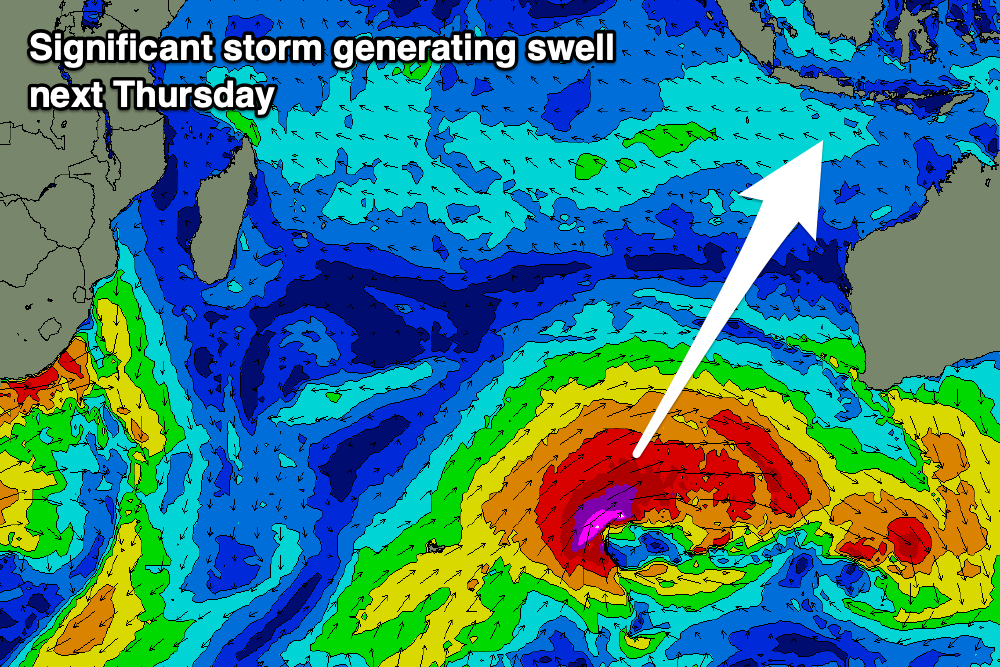
We then look at the new swells due into the end of the week, with Wednesday’s initial SW groundswell due to be followed by a large, significant long-period S/SW groundswell Thursday.

The source of these swells is a strong, north protruding cold outbreak from the Southern Ocean, with an initial mid-latitude low due to generate a moderate sized SW groundswell Wednesday, while a secondary, broad slingshot of severe-gale SW winds moving up behind the low should generate Thursday’s swell.
The timing has been brought forward a little with this swell due to fill in strongly Thursday, peaking later before easing slowly into Friday.
We may see a moderate + sized reinforcing S/SW swell for next weekend, slowing the easing trend but we’ll review this next Tuesday.
Longer term, a couple of strong lows spawning off South Africa look to generate some good, moderate to large sized SW groundswell for the following week but check the next update.
----------------------------------------------
The current moderate + sized SE trade-swell across the Maldives will persist over the coming days, with a good reinforcing pulse due tomorrow, easing slowly from later Saturday but more so Sunday and further next week owing to the broad and expansive fetch of E/SE trades slowly weakening over the coming days.
A low point is likely next Thursday before a new fetch of SE trades start to develop south-east of the region, but not to the strength or area as the current setup.
The strong cold outbreak in the Indian Ocean should also generate some moderate + sized S/SE groundswell for the Maldvies, arriving next Friday and peaking into the afternoon to 4-5ft across the southern atolls.
The swells following this look good as well, offering larger S/SW groundswell energy into the following week.
Eastern Indonesia:
Easing surf today and tomorrow.
Moderate sized, mid-period S/SW swell Saturday to 4-5ft+, easing Sunday.
Inconsistent, small background SW groundswell Monday.
Moderate sized SW groundswell Wednesday to 4-5ft+.
Large S/SW groundswell building strongly Thursday, reaching 8-10ft later, easing Friday.
Reinforcing moderate + sized S/SW groundswell for the following weekend.
Moderate to fresh E/SE-SE trades (stronger tomorrow and Saturday), with variable winds each morning.
Uluwatu 16-day Forecast Graph/WAMs
Western Indonesia/Mentawais/South Sumatra:
Moderate sized mid-period S’ly swell Saturday to 4-5ft+, easing Sunday.
Moderate sized S trade-swell Friday through Monday, smaller next week.
Inconsistent, small background SW groundswell Monday.
Moderate sized SW groundswell later Tuesday and Wednesday morning to 4-5ft+.
Large S/SW groundswell building strongly Thursday afternoon, reaching 8ft, easing Friday.
Fresh to strong S/SE-SE winds, slowly easing through next week, variable Thursday/Friday.
Mentawai 16-day Forecast Graph/WAMs
Maldives:
Large, persistent pulses of SE trade-swell tomorrow and Saturday, coming in either side of 6ft across exposed breaks, less consistent into the weekend and easing slowly from Sunday.
SE trade-swell continuing to ease through next week, reaching 3ft next Thursday.
Moderate sized S’ly groundswell Monday to 3-5ft on the southern atolls.
Building S/SE groundswell next Friday to 4-5t across the southern atolls.
Building SE trade-swell next Friday through the weekend, with some larger S’ly groundswell for the week starting the 5th.
Fresh to strong W-W/SW winds across northern and central locations, variable to the south through until Tuesday.
S’ly winds developing across southern locations Tuesday, tending E/SE-SE from Wednesday with weaker W winds to the north.


Comments
Latest notes are live.
Hey Craig reckon that swell next thursday has enough juice in it for them to run the Padang cup? 1st day of the waiting period..
Looks like they'll run the trials. We're the official forecaster.
Awesome. Great start to the month for em, Thanks man!
Looks like a couple of weeks of proper consistent pumping waves coming up !
Hi Craig, hope you and family are well and no doubt busy . Looking forward to Thursday update on forecast notes , that swell that’s due to arrive around 13th august looks real interesting .
Supa, just doing today's now :)