Indonesia/Maldives forecast Jul 23
Indian Ocean Basin analysis by Craig Brokensha (issued Tuesday 23rd July)
This week through next (Jul 24 - Aug 2)
We’ve got some fun, large S/SW swell energy in the water across eastern Indonesia, with smaller surf to the west owing to the generation location. That being off the Western Australian coastline.
A reinforcing pulse of S/SW energy is due this afternoon, easing slowly through tomorrow, with a smaller pulse due into Thursday, slowing the easing trend.
All in all, this afternoon and early tomorrow should reveal the most size, tailing off into the end of the week.

On Saturday, a moderate sized, mid-period S/SW swell is due, generated by a weak frontal system that’s currently projecting towards Western Australia. With wind speeds not reaching gale-force, moderate sized surf is due, easing into Sunday and bottoming out Monday with some small, inconsistent background SW groundswell.
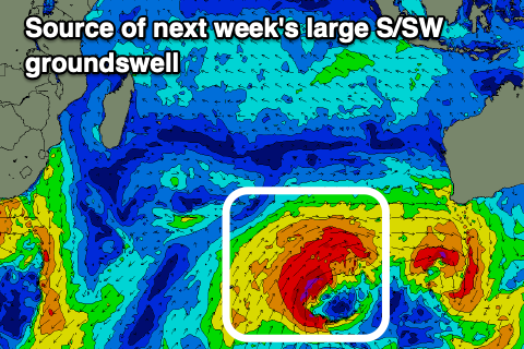
The next source of swell will be a moderate sized SW groundswell on Wednesday followed by larger S/SW groundswell Thursday afternoon and Friday.
Wednesday’s increase will be produced by a small, tight low at the head of a stronger and broader polar frontal system projecting up high into the Indian Ocean.
The models are in agreement with this progression and with that confidence is high for both swells. Size wise, the largest swell looks to peak around 8ft to possibly 10ft on the magnets but we’ll review this Thursday.
----------------------------------------------
Looking at the Maldives and our large SE trade-swell from late last week and the weekend has settled a touch but the surf is still strong and we should see it continuing most of this week thanks to a broad, elongated fetch of E/SE trades through the northern Indian Ocean.

The fetch strength looks a touch weaker and this will result in the period easing a touch but large surf should persist all this week, easing slowly from Sunday but more noticeably through next week thanks to the fetch weakening through the weekend and next week.
Otherwise, S’ly swell pulses look limited, with the best due through early next week, generated by a low that’s currently spawning off South Africa.
A moderate sized S’ly groundswell is expected, peaking Monday, while the activity generating Indonesia’s large groundswell later next week should produce some large, side-band energy later next week but we’ll look at this in more detail Thursday.
Eastern Indonesia:
Large S/SW groundswell for this afternoon to 6ft to occasionally 8ft, easing from a similar size early tomorrow, fading slowly through the rest of the week.
Moderate sized, mid-period S/SW swell Saturday to 4-5ft+, easing Sunday.
Inconsistent, small background SW groundswell Monday.
Moderate sized SW groundswell building later Tuesday, peaking Wednesday to 4-5ft.
Large S/SW groundswell building strongly Thursday afternoon, reaching 8ft+, easing from a similar size Friday morning.
Moderate E/SE-SE trades, fresh at times and with variable winds each morning. Slightly stronger trades late week and on the weekend, easing a touch next week.
Uluwatu 16-day Forecast Graph/WAMs
Western Indonesia/Mentawais/South Sumatra:
Moderate + sized S/SW groundswell for today/tomorrow to 6ft across exposed breaks, easing into the end of the week.
Moderate sized mid-period S’ly swell Saturday to 4-5ft+, easing Sunday.
Moderate sized S trade-swell Friday through Monday, smaller next week.
Inconsistent, small background SW groundswell Monday.
Moderate sized SW groundswell building later Tuesday, peaking Wednesday to 4-5ft+.
Large S/SW groundswell building strongly Thursday afternoon, peaking to 8ft Friday morning.
Fresh to strong S/SE-SE winds, slowly easing through next week.
Mentawai 16-day Forecast Graph/WAMs
Maldives:
Large, persistent pulses of SE trade-swell this week, coming in either side of 6ft, less consistent into the weekend and easing slowly from Sunday.
Moderate sized S’ly groundswell Monday to 3-5ft on the southern atolls.
Larger S’ly groundswell later next week to 5-6ft across the southern atolls.
W/SW winds across northern and central locations, E/SE to the south over the coming days.
Strengthening W-W/NW winds across northern and central locations Friday and this weekend, variable to the south. Easing winds next week.


Comments
The latest notes are live.
Cheers Craig! Flying out tomorrow for a month. Relieved to see some swell forecasted!
Haven't been following too closely, but it feels like this has been the best Indo season for a few years. Maybe not much in the XXL department but plenty of good sized swells.
What do you reckon Craigos?
Actually reports are the opposite, no really big, consistent swells, just a couple. Plenty for the average punter though.
Keeping in mind some spots need the big stuff, and they've been really slow.
Yeah okay interesting. I've been seeing a lot from G-land. Seems like they've been doing well there.