Indonesia/Maldives forecast Jul 4
Indian Ocean Basin analysis by Craig Brokensha (issued Thursday 4th July)
This week through next (Jul 5 - 12)
Yesterday’s initial increase in SW groundswell didn’t really show and today’s larger S/SW energy is yet to also make any real impact. It did go XL across Western Australia though and should be in the water soon with a peak now likely to occur tomorrow morning.
This energy is due to ease into the weekend, slowed by an inconsistent, reinforcing pulse of energy Sunday afternoon.

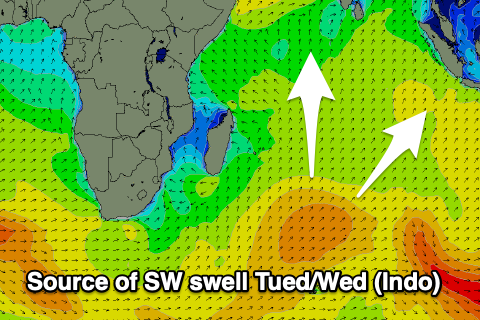
Most of next week will be slow with background, small to moderate levels of swell (best Tuesday/Wednesday) as a fun new SW pulse arrives) but later in the week and more so next weekend, we should see our next episode of moderate to possibly large sized swell filling in from the S/SW.
It’ll be mid-period, generated by a northward projecting polar front high up into the Indian Ocean early next week, but wind strengths will hardly reach gale-force.
With this it may put a limit on the size to the 6ft+ range but we’ll review this next week.
----------------------------------------------
We’ve got an easing mix of SE trade-swell and S’ly groundswell across the Maldives region, with this due to continue through tomorrow, further into Saturday.
From Sunday afternoon and more so Monday some new mid-period S’ly and S/SE trade-swell is due, with the trade-swell generated by a burst of SE trade-winds east of Madagascar over the coming days.
The S’ly swell from a healthy but not overly strong frontal system that projected up south-east of Madagascar the last couple of days.
Both look to ease back slowly through the week ahead of some new S’ly groundswell from the high projecting frontal progression Thursday afternoon/Friday. It only looks moderate in size but we’ll review this next week.
Eastern Indonesia:
Larger S/SW groundswell tomorrow to 8ft on the sets across the magnets, 6ft+ elsewhere, easing later and further into Saturday.
Inconsistent, reinforcing S/SW groundswell Sunday afternoon to 3-5ft.
Moderate sized mid-period SW swell building Tuesday, reaching 4-5ft+ late, easing from a similar size Wednesday.
Moderate + sized mid-period S/SW swell for later next week to 6ft+.
Strong E/SE-SE trades today and tomorrow, easing into the weekend and next week (possibly strengthening again later week. Variable winds each morning.
Uluwatu 16-day Forecast Graph/WAMs
Western Indonesia/Mentawais/South Sumatra:
Large S/SW groundswell to 6-8ft across exposed breaks tomorrow morning, easing.
Smaller, reinforcing S/SW groundswell Sunday afternoon to 4ft.
Moderate + sized mid-period SW swell for Tuesday, building to 4-6ft across exposed breaks during the day, easing Wednesday.
Moderate sized + mid-period S’ly swell next Friday to 6ft+ across exposed breaks.
Variable winds, tending NW over the coming days, possibly S/SE-SE later next week.
Mentawai 16-day Forecast Graph/WAMs
Maldives:
Mix of easing SE trade-swell and S’ly swell from 4-5ft+ across most locations tomorrow, smaller Saturday.
Moderate + sized mix of S’ly groundswell and smaller S/SE trade-swell building Sunday, reaching 3-5ft across the southern atolls into the afternoon, easing Monday.
Moderate sized SE trade-swell to 3-4ft early next week, easing slowly mid-late week.
Possibly moderate + sized S’ly groundswell later week.
S/SE winds across southern locations tomorrow, W/SW-SW to the north, similar Saturday through Wednesday. W/NW winds later next week.


Comments
Latest notes are live. Any signs of the larger stuff yet?
Some overhead sets today craig ( 4ft ) but not that many , pulsed on the outgoing tide for about an hour , tonight starting to pick up gradually, tomorrow after high tide should be on …….. hopefully
Yeah never really came in with solid size, just a few moments and it's super rare for this being a kinda hoax swell.
In saying that off the coast we had a wet season type day of weather yesterday so whether it was chopped at from that I'm not sure.
Bummer. First one this year that's missed. Was a bit worried seeing the lack of size yesterday morning.
Some good 5ft plus sets today, out at muntigs had 6-8ft bombs, dropped off quickly with the low tide. Got 4 barrels out at the wreck and didn’t make one of them, kept getting clamped on the end . 3 boards broken, fortunately not mine . A goofyfooter out at razors was getting some great barrels .
Agh k. Still 8ft sets around.
Had a really nice session today 3-4 ft with some 5ft sets occasionally , some good pulses , 5 waves sets consistently for 40 minutes then fuck all for 30 minutes, much better shape today and made a few barrels.
Very nice.