Indonesia/Maldives forecast June 25
Indian Ocean Basin analysis by Craig Brokensha (issued Tuesday 25th June)
This week through next (Jun 26 - Jul 4)
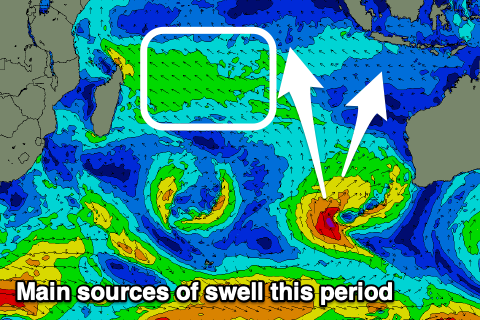
After a couple of slow days we’ve got a new mid-period S/SW swell on the build this afternoon, generated by a mid-latitude low projecting up off the Western Australian coast late last week and into the weekend.

A peak is due this evening with it easing steadily tomorrow, further into Thursday.
Friday looks to remain on the smaller side with a long-range SW groundswell only due to generate infrequent, small-moderate sized sets.
As touched on last week, the rest of the period looks mixed and not overly reliable with funky mid-latitude systems in the Indian Ocean due to generate moderate sized + pulses of mid-period swell.
One of these us currently west of Western Australia, generating a weak fetch of SW winds, though it’s expected to strengthen a little while projecting slowly north closer towards eastern Indonesia the next two days.
This should generate a moderate + sized pulse of energy for Saturday afternoon and more so Sunday, easing back through Monday though mixed in with some long-range groundswell.

The low is favourabnly aimed for the Mentawais and as a result they’ll see plenty of size as well this low across south magnets.
Following this, a better Southern Ocean frontal progression is forecast for later this week and the weekend, generating some stronger, moderate to large pulses of SW groundswell for later next week and weekend. We’ll take a closer look at this on Thursday though.
----------------------------------------------
The Maldives is seeing a good run of S/SE-SE trade-swell, moderate to large in size thanks to a robust fetch of E/SE-SE trades through the northern Indian Ocean.
The fetch is due to weaken slightly in our swell window while strengthening right off Madagascar this week and with this we’ll see the size slowly dropping away into the middle to end of the week, further on the weekend.
A re-strengthening of the trades should see the swell kick back up through next week though, moderate + in size.
The low off Western Australia should also generate a less consistent but good pulse of mid-period SE swell for Sunday/Monday.
We then look at the developments in the Southern Ocean and at this stage we can expect moderate + sized pulses of S’ly groundswell into next week. We’ll look at this closer on Thursday.
Eastern Indonesia:
Moderate + sized mid-period S/SW swell peaking later this afternoon to 4-6ft, easing from 4-5ft+ tomorrow morning.
Inconsistent, background SW groundswell Friday to 3-4ft+ across the magnets.
Moderate sized + mid-period S/SW swells building Saturday, peaking Sunday to the 6ft range across the magnets, easing Monday.
Stronger SW groundswell likely later next week.
Gusty E/SE-SE trades tomorrow, weaker from Thursday (lighter and more variable each morning). Trades strengthening a little again from Sunday/Monday into next week.
Uluwatu 16-day Forecast Graph/WAMs
Western Indonesia/Mentawais/South Sumatra:
Small sized mid-period S/SW swell today to 4-5ft, easing tomorrow.
Inconsistent, background S/SW groundswell for later Thursday and Friday to 4-5ft.
Moderate + sized mid-period S swell building later Saturday, peaking Sunday to 6ft across exposed breaks.
Larger SW groundswell for later next week.
Variable winds, freshening from the E/SE-SE across southern locations Sunday.
Mentawai 16-day Forecast Graph/WAMs
Maldives:
Moderate to large levels of S/SE-SE trade-swell over the coming days, 5-6ft today across the magnets, easing back to 4-6ft from tomorrow and holding most of the week, easing very slowly during the weekend.
Inconsistent mid-period S/SE swell for later Sunday, peaking Monday to 4ft+.
Moderate + sized S’ly groundswell for early next week to 4-5ft+ across the southern atolls.
Re-strengthening SE trade-swell again through next week.
Moderate W/SW-SW winds, weaker S’ly across southern locations. Winds tending S’ly on the weekend, SE across southern locations.


Comments
Latest notes are live.
Re-strengthening SE trade-swell again through next week, how do you see the trades going into 2nd week of July Craig, thinking of going to Kandooma
Hi Craig,
Back in April/May there was a story about the IOD and predicted cold water upwelling around Bali/Java. Has the cold water upwelling and generally stronger trades been experienced as forecast. Starting to pack gear for a fortnight in Indo and hoping I can leave the 4/3 and hood behind. Steve
Hey Steve, the water has warmed across most locations with the IOD returning to neutral. There are spots from East Java further east that are still a touch cooler than normal (-1°C).
Check it here..

Thanks Craig. it looks toasty!