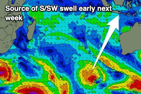
Indonesia/Maldives forecast June 18
Indian Ocean Basin analysis by Craig Brokensha (issued Tuesday 18th June)
This week through next (Jun 21 - 28)
Our large, new S/SW groundswell for tomorrow is on track, with it performing well in Western Australia, peaking yesterday and then easing steadily today.
We should see it building strongly through tomorrow, peaking into the evening, then easing steadily through Saturday, smaller into Sunday and Monday.

We’ve then got our moderate sized, mid-period S/SW swell for later Monday and Tuesday on the cards, produced by a relatively weak but favourably projecting low that’s currently south-west of Western Australia.
A fun swell is due from this system, peaking into the afternoon and easing Wednesday, smaller Thursday.
Unfortunately the follow up mid-period energy for later in the week and weekend now looks a bit wishy-washy with no consolidated storm activity now on the cards. Instead mid-latitude lows look to generate some funky south swells that look moderate + in size.
We’ll have a closer look at this on Tuesday.
----------------------------------------------
As touched on in Tuesday’s update, the coming period will be dominated by swells from the south-east and south-east owing to the storm activity in the westerly storm track slowing down.

Persistent fetches of strong E/SE-SE winds through the northern Indian Ocean will generate moderate levels of background swell, while an intensification of the fetch, east of Madagascar later next week should see larger surf develop later next week onwards out of the S/SE.
Southerly swell wise, there are pulses of background energy but they’ll be hidden under the more consistent S/SE-SE swell energy.
Eastern Indonesia:
Large, S/SW groundswell building tomorrow, peaking later to 6ft+, easing from the 6ft range Saturday morning.
Moderate + sized mid-period S/SW swell for later Monday, peaking Tuesday afternoon to 4-6ft, easing from 4-5ft+ Wednesday morning.
Moderate sized + mid-period S/SW swells for later Friday through next weekend likely to 4-6ft across exposed breaks.
Moderate to fresh E/SE-SE trades, lighter and more variable each morning. Stronger trades Sunday/Monday.
Uluwatu 16-day Forecast Graph/WAMs
Western Indonesia/Mentawais/South Sumatra:
Moderate + sized S/SW groundswell building later tomorrow to 5-6ft, easing from 4-6ft Saturday morning.
Small sized mid-period S/SW swell for later Monday, peaking Tuesday to 4-5ft.
Moderate + sized mid-period S/SW swell building Friday, reaching 4-6ft, easing Saturday.
Variable winds, strengthening from the E/SE-SE across southern locations from Sunday, persisting most of next week but more so moderate in strength.
Mentawai 16-day Forecast Graph/WAMs
Maldives:
Mid-period SE swell for today to 4-5ft, easing tomorrow and into the weekend.
Building levels of S/SE-SE trade-swell through Sunday, becoming larger next week and reaching 5-6ft across the magnets.
Possible larger S/SE swell energy later next week and onwards.
Moderate to fresh W/SW-SW winds, strong at times with passing instability. Weaker winds likely developing mid-late next week.


Comments
Latest notes are live.
Hi Craig, what does your crystal ball say about Maldives, early to mid July, specifically Kandooma. SE trade swells set up, they had funky winds mid to late May
Everywhere up there had shit winds in May. One of the worst Mays I’ve seen in the Maldives for both winds and swell.
Thanks Don, I was just looking at the forecasts/observations without that much knowledge of the archipelago so that confirms my observations. I nearly went to Ayada mid April but pulled the pin as the IO basin was on the quite side
After a slow start to the day with the high tide it started to absolutely pump with the run out tide , 3-5 ft with bombs thrown in , june has been pretty awesome and even though it backs off for a week starting tomorrow , there still should be waist to head high , hopefully early July forecast holds .