Indonesia/Maldives forecast May 30
Indian Ocean Basin analysis by Craig Brokensha (issued Thursday 30th May)
This week through next (May 31 - Jun 7)
We’ve got easing surf across the region, with it due to continue through tomorrow though slowed a little thanks to a reinforcing pulse of mid-period S/SW swell energy during the afternoon.
The magnets should maintain 6ft+ surf before easing back through Saturday, smaller into Sunday.
We then look at our run of large SW and S/SW groundswell into next week, with a progression of healthy but not overly significant storms now due to push up through the Indian Ocean under the influence of a strong node of the Long Wave Trough.
What they don’t pack in strength, they pack in breadth along with each storm moving on top of an already energised sea state, helping to amplify swell generation.
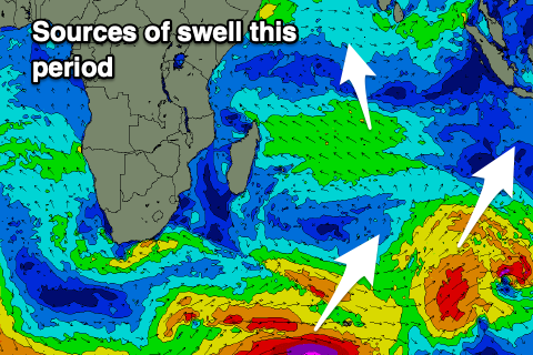
On Monday, an inconsistent long-period SW groundswell is due to fill in, with it generated by a strong but distant low firing up south-east of South Africa earlier this week.
The system has since weakened, with the remnants now projecting towards us, with a broad fetch of strong S/SW winds due to generate some larger, more consistent mid-period swell for Tuesday.

On top of this though, a secondary front will generate stronger gale-force winds and some larger, long-period S/SW groundswell that should also be in the mix Tuesday, peaking through the afternoon.
A third similar strength front then spinning up on all the activity should produce yet another long-period S/SW groundswell for Wednesday, easing into the end of the week.
The downtrend will be short-lived, with a more significant polar storm this weekend due to generate a less consistent, large SW groundswell for Friday afternoon and Saturday week, followed by further activity. More on this next Tuesday.
Over in the Mentawais, we’re still expecting funky levels of mid-period W/NW swell to build back through the coming days, peaking over the weekend and easing slowly next week thanks to a surge of W’ly monsoon winds south of Sri Lanka. These winds are interfering with the northern regions but will slowly retreat through the weekend.
----------------------------------------------
Looking at the Maldives and the strong W’ly winds from the stalling MJO signal will slowly back off into next week, but remain fresh even into the late week.
These winds will continue to add westerly swell contamination to the mix as well as making for tricky surfing conditions, improving slowly as the winds back off slowly next week.
Swell wise a good pulse of SE trade-swell yesterday should be easing a touch today, before pulsing again Saturday and then easing again Sunday. This is with the intensification and weakening of local trades through the Indian Ocean.
The S’ly groundswell energy from the strong storms firing up towards Indonesia are due to arrive through the weekend, the first Saturday ahead of the largest pulse due later Sunday and into Monday morning.
As this energy eases through Tuesday, our more robust episode of S/SE trade-swell energy is due to fill in, generated by a re-strengthening of the SE trades to the south-east of the region from tomorrow through the weekend.
A peak in size is due Tuesday, easing slowly for the rest of the week as the trades again relax.
We’ll then see more large S’ly groundswell pulses later in the week from the polar low firing up to the south-east of South Africa, but more on this Tuesday
Eastern Indonesia:
Reinforcing mid-period S/SW swell filling in tomorrow, maintaining 6ft+ sets across exposed breaks, easing Saturday and Sunday.
Large, long-period SW groundswell building later Sunday but more so Monday to 6ft to occasionally 8ft into the evening.
Larger S/SW groundswell Tuesday, building to 8ft to occasionally 10ft, with a secondary similar sized reinforcing pulse for Wednesday, easing Thursday.
Large, inconsistent SW groundswell building Friday, peaking Saturday to 8ft.
Weak, funky trades tomorrow, locally light offshore each morning, freshening E/SE trades slowly from the weekend and more so into next week.
Uluwatu 16-day Forecast Graph/WAMs
Western Indonesia/Mentawais/South Sumatra:
Easing S/SW swell over the coming days, bottoming out Sunday morning.
Persistent, small-moderate sized mid-period W/NW swell across northern locations, peaking on the weekend, easing slowly next week.
Large, long-period S/SW groundswell building later Sunday but more so Monday to 6-8ft.
Larger S/SW groundswell Tuesday, to 8ft to occasionally 10ft, with a secondary similar sized reinforcing pulse for Wednesday, easing Thursday.
Large, inconsistent SW groundswell building Friday, peaking Saturday morning to 8ft.
Variable winds, tending S/SE across southern locations from Sunday.
Strong S winds across northern locations this week, easing into next week.
Mentawai 16-day Forecast Graph/WAMs
Maldives:
Mid-period W’ly swell in the mix across selected locations this week and next.
Small-moderate sized SE trade-swell Saturday to 4ft.
Moderate + sized S’ly groundswell Saturday to 4-5ft across the southern atolls, easing Sunday.
Large pulse of long-period S’ly groundswell Sunday afternoon to 6ft+ across the southern atolls, easing slowly from a similar size Monday.
Moderate-large S/SE trade-swell building next week, reaching 4-6ft Tuesday, easing slowly into the end of the week.
Large pulse of long-period S’ly groundswell Thursday/Friday to 6ft+ across the southern atolls.
Strong W-W/NW winds, easing off a touch Sunday but persisting into next week (moderate to fresh).


Comments
Latest notes are live. Jam packed!
https://www.baliwaves.com/2024/05/g-land-surf-report-joyos-g-land-surf-c...
Where's McGroder . . .
Enormous. Looks deceptively playful before it hits the inside.
Today was bigger than yesterday , channel closed out on 3 separate sets from razors to shipwreck on high tide , looking forward to the footage from around indo .
Pumpin in Nth Male today.
Thanks for the updates guys, all about as expected :)
some insane footage