Indonesia/Maldives forecast May 28
Indian Ocean Basin analysis by Craig Brokensha (issued Tuesday 28th May)
This week through next (May 29 - Jun 7)
The large pulse of SW groundswell due across the region today has come in strong with large sets from the get go under light winds, with a peak due into this afternoon/evening.
There’s no change to the expected size, but our reinforcing pulse of S/SW groundswell for Thursday has been brought forward to later tomorrow, with it also peaking overnight and easing Thursday.
The reason being that the secondary strong storm firing up towards Western Australia, linked to it, came in stronger than forecast last Thursday. A significant low pressure cell formed, with a burst of storm-force winds producing an XL spike in swell for WA yesterday.
This was a quick pulse and similar is expected across Indonesia, with it impacting Java to just east of Bali most.
Following this it’ll be down from Friday through Saturday and Sunday ahead of our next round of large SW groundswell.
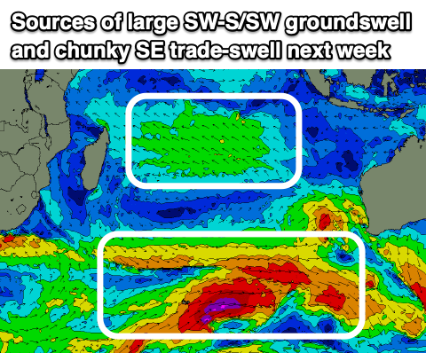
This coming episode looks to likely be more prolonged compared to the current large swells, with a series of strengthening polar systems from under South Africa due to slow and broadening in scope while projecting towards us over the coming week.
There’ll be a large train of incoming frontal systems, all firing up under the influence of a stalling node of the Long Wave Trough.
At this stage all the activity looks to come in around a similar size to today’s large peak, though there is potential for one of the swells in the coming episode spiking above this.

We’ll have to continue watching the evolution of this progression but in short, the first spike in size is due Monday, with a large long-period SW groundswell due to build into the afternoon/evening followed by larger pulses Tuesday and Thursday.
Weaker trades this week are due to strengthen into next week, grooming the swell nicely.
Over in the Mentawais, funky levels of mid-period W/NW swell are due to build back through this period, peaking over the weekend thanks to a surge of W’ly monsoon winds south of Sri Lanka. These winds look to migrate east and interfere with the northern regions from tomorrow, easing into next week.
----------------------------------------------
Looking at the Maldives and the main issue right now are these strong winds from the western quadrant thanks to an active, stalling MJO signal. It’s ruining conditions across select spots and making it very tricky.
They unfortunately look to persist this week, strengthening more from tomorrow, abating a touch into the weekend though persisting next week.
This will add westerly swell contamination to the mix as well as making for tricky surfing conditions.
Swell wise, yesterday’s large S’ly groundswell is on the ease but SE trade-swell is muscling up with a healthy fetch of SE trades setting up in the central Indian Ocean.
Various pulses are due from tomorrow through the weekend, with the strongest peaking tomorrow with moderate + sized sets.
The south-east swell generating trades are due to weaken temporarily over the coming days before coming back even stronger from the weekend, generating larger levels of S/SE trade-swell for next week.
Looking at the southern swell window, and the storms firing up under South Africa will produce back to back, increasing pulses of S’ly groundswell, the first for Saturday, moderate + in size, with a secondary larger pulse for later Sunday but more so Monday.
More swell is due later next week, but we’ll review this Thursday.
Eastern Indonesia:
Large SW groundswell building today, reaching 8ft+ into the afternoon, easing slowly Wednesday from a similar size.
Large, short-lived sike of reinforcing S/SW groundswell to 8ft+ tomorrow afternoon/evening, easing from 6-8ft Thursday, smaller into the weekend.
Large, long-period SW groundswell building later Sunday but more so Monday to 6ft to occasionally 8ft into the afternoon.
Larger swell Tuesday to 8ft+, easing a little Wednesday.
Weak, funky trades over the coming days, locally light offshore each morning, fresher E/SE trades from Friday and into next week.
Uluwatu 16-day Forecast Graph/WAMs
Western Indonesia/Mentawais/South Sumatra:
Large S/SW groundswell today to 8ft+, easing slowly tomorrow.
Reinforcing S/SW groundswell for later tomorrow and Thursday morning to 6ft to possibly 8ft, easing Friday and further into the weekend.
Persistent, small-moderate sized mid-period W/NW swell across northern locations, peaking on the weekend.
Variable winds, tending S/SE across southern locations and fresh on Thursday, tending variable from Friday.
Strong S winds across northern locations this week, easing into next week.
Mentawai 16-day Forecast Graph/WAMs
Maldives:
Mid-period W’ly swell in the mix across selected locations this week and next.
Small-moderate sized SE trade-swell pulsing this week, reaching 4-5ft tomorrow, easing slowly into the end of the week, with a reinforcing pulse Saturday to 4ft.
Easing S’ly groundswell tomorrow from 3-4ft across the southern atolls
Mid-period W’ly swell in the mix across selected locations this week and next.
Moderate + sized S’ly groundswell Saturday to 4-5ft+ across the southern atolls, easing Sunday.
Late pulse of long-period S’ly groundswell Sunday, peaking Monday to 6ft+ across the southern atolls, easing slowly.
Moderate-large S/SE trade-swell building next week, reaching 5-6ft Tuesday, easing slowly into the end of the week.
Strong W-W/NW winds, becoming even stronger over the coming days, easing off a touch on the weekend but persisting and into next week.


Comments
Latest notes are live.