Indonesia/Maldives forecast May 21
Indian Ocean Basin analysis by Craig Brokensha (issued Tuesday 21st May)
This week through next (May 22 - 31)
Following a small, inconsistent pulse of background energy today, we’ve got smaller surf due over the coming days, bottoming out into Thursday.
On Friday a small, inconsistent background SW groundswell should build, peaking through Saturday. The source was nothing standout so expect slow 4ft+ sets at the most later Friday on the magnets, easing from a similar size Saturday.
Into Sunday a small pulse of reinforcing SW swell should be seen Sunday, generated by a brief low forming north-east of the Heard Island region over the coming days.
A better increase in size to 4-5ft+ is due across the magnets through the day, easing back through Monday.
We then look at our stronger pulses of SW groundswell due into the middle of next week and while not as big as the models are showing, it’s the most significant swell for a few weeks across the region.
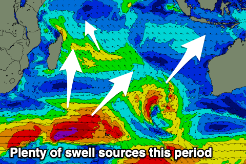
The source of these swells will be a progression of strong frontal systems migrating up towards Western Australia from under South Africa, starting today and continuing into early next week.
At this stage, the first swell producer looks the strongest, with a great fetch of gale to severe-gale W/SW winds due to move through Indonesia’s south-western swell window, generating a large, long-period SW groundswell for Tuesday, with the forerunners arriving later Monday.
A peak is due into the afternoon Tuesday, easing slowly Wednesday, followed by a secondary strong swell generating storm and large, reinforcing S/SW groundswell pulse Thursday/Friday.

Following this there’s plenty more activity on the cards, generating moderate-large surf into the start of June, but more on this Thursday.
For the Mentawai’s it's worth noting a funky mid-period W/NW swell is due over the coming days, generated by strong W’ly winds around The Maldives and Sri Lanka, linked by a strengthening MJO signal.
It’s these winds that actually look to kill off the possible + IOD event for this coming season, with it preventing upwelling S/SE winds to kick in. Positive news all around.
----------------------------------------------
Over to the Maldives and moderate + levels of S/SE trade-swell are breaking across the region but with strong W-SW winds owing to the deepening of a tropical low south of the region.
The S/SE swell energy will ease into tomorrow, but some new S’ly groundswell should arrive during the day, generated by a strong frontal progression under South Africa late last week.
A peak is due into the afternoon, easing into Thursday as a fresh pulse of mid-period S’ly swell fills in.
The source will be a surge of strong SE winds to the east of Madagascar today and tomorrow, then, combining with a broader fetch of weaker SE winds to the south-west of Indonesia.
This will produce background levels of SE swell that should build through the weekend, holding early next week before likely increasing more in size later week.
But of greater significance will be the S’ly groundswell energy from the strong fronts firing up through Indian Ocean. The strongest is due next Monday, reaching the moderate to large size range, easing through the week.
The strong winds currently impacting the island should start to ease into next week as the tropical activity migrates towards India.
Eastern Indonesia:
Easing background swell tomorrow and Thursday.
Inconsistent SW groundswell building later Fri, peaking Saturday to 4ft+ across the magnets.
Secondary S/SW groundswell building Sunday, reaching 4-5ft+ into the afternoon, easing Monday.
Large SW groundswell building Tuesday, reaching 8ft+ into the afternoon, easing slowly Wednesday from a similar size.
Reinforcing S/SW groundswell to 6-8ft Thursday/Friday.
Moderate to fresh E/SE trades (weaker over the coming days and stronger early next week), variable offshore each morning.
Uluwatu 16-day Forecast Graph/WAMs
Western Indonesia/Mentawais/South Sumatra:
Easing S/SW swell over the coming days with a funky-mid-period W/NW swell in the mix to 3-5ft across northern regions, easing Friday.
Moderate sized S/SW groundswell for later Thursday and Friday to 4-5ft on the magnets, holding Saturday.
Reinforcing S/SW groundswell Saturday afternoon and Sunday to 4-5ft.
Large S/SW groundswell building later Monday, reaching 8ft+ into Tuesday, easing slowly Wednesday.
Reinforcing S/SW groundswell to 6-8ft Thursday morning.
Variable winds, tending S/SE from Friday across southern locations and strengthening, persisting until Monday next week, then weakening.
Mentawai 16-day Forecast Graph/WAMs
Maldives:
Moderate sized S/SE trade-swell to 4-5ft+ across the southern atolls this morning, smaller to the north, easing tomorrow.
Moderate + S’ly groundswell building tomorrow, peaking into the afternoon to 4-5ft across the southern atolls, smaller to the north, easing Thursday.
New moderate + sized mid-period S’ly swell Thursday to 4-5ft+ across the southern atolls, easing Friday.
Small-moderate sized SE trade-swell building through the weekend, reaching 4ft Sunday and persisting most of next week before increasing more later week.
Moderate to large S’ly groundswell building Monday, reaching 4-6ft into the afternoon across the southern atolls, easing Tuesday.
Weak W’ly windswell in the mix across selected locations this week.
Strong W/SW winds (SW across southern locations) tomorrow through Friday, easing slightly into the weekend but persisting next week.


Comments
The latest notes are live.
looking tasty!
Where is the best place to see the Maldives long term forecast? Doesn't look like there is one, so what would be the best proxy? Also curious why there isn't one, technical issue?
No we don't but will do in the future.
What might've once been a smart idea to escape the stronger SE trades and head further NW in the archipelago might bite you on the ass with this installment of SW winds looking to persist for a while