Indonesia/Maldives forecast May 14
Indian Ocean Basin analysis by Craig Brokensha (issued Tuesday 14th May)
This week through next (May 15 - 24)
After bottoming out into yesterday, some inconsistent mid-period S/SW swell is due to arrive later today, peaking through tomorrow, generated by a small, tight polar low on the polar shelf last week.
We’ve then got our inconsistent levels of SW-S/SW groundswell due later in the week, generated by a slightly stronger polar low that developed west of the Heard Island region late last week and pushed ease over the weekend.
It’ll be inconsistent with moderate sized surf due into Friday, peaking through the afternoon/evening, easing slowly through Saturday, smaller Sunday.
We’ve then got a smaller run of surf due through next week and into the following weekend with the Indian Ocean not really offering anything too special storm wise.
We’ll see funky mid-latitude lows and weakening frontal systems generating small to moderate pulses of energy but at this stage nothing really stands out.
----------------

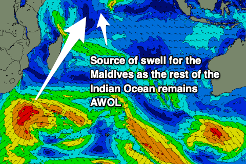
Over to the Maldives and we’ve got a small-moderate sized mix of background SE trade-swell and easing S/SE swell from a fetch directly east of Madagascar.
The swell will continue to ease into tomorrow, with some new background S’ly groundswell for Thursday, followed by a slightly stronger increase later Friday, peaking Saturday.
Strengthening W-W/SW winds linked to a deepening tropical low in our region will also add some W’ly windswell contamination from late week through the weekend and next week to selected spots though it shouldn’t be too hard to escape this.
They will make for tricky, blustery conditions though.
Otherwise we’ve got lots of additional S’ly groundswell pulses due into next week thanks to back to back storms firing up under South Africa. There should also be some good S/SE trade-swell in the mix early next week, shifting SE owing to a restrengthening of the fetch east of Madagascar.
All in all this points to an active period of surf for the region.
Eastern Indonesia:
Small-moderate sized S/SW groundswell building late today, peaking tomorrow to 4-5ft across exposed breaks, easing Thursday.
Moderate sized, inconsistent S/SW groundswell building Friday afternoon to 4-6ft across exposed breaks, easing Saturday from a similar size.
Small-moderate sized background swell for Tuesday to 4ft.
Moderate to fresh E/SE trades (weaker tomorrow and stronger early-mid next week), variable offshore each morning.
Uluwatu 16-day Forecast Graph/WAMs
Western Indonesia/Mentawais/South Sumatra:
Moderate sized, inconsistent S/SW swell building later today, peaking tomorrow to 4-5ft across exposed breaks.
Moderate sized, inconsistent S/SW groundswell for Friday, building to 4-5ft+, easing Saturday.
Small-moderate sized background swell for Monday in the 4ft range.
Variable winds, tending S/SE through Friday across southern locations. Possible stronger S/SE winds across southern locations next week.
Mentawai 16-day Forecast Graph/WAMs
Maldives:
Easing SE trade-swell tomorrow but not below 3ft.
Inconsistent S’ly groundswell Thursday to 3-4ft on the southern atolls.
Stronger S’ly groundswell for later Friday, peaking Saturday to the 4ft+ range on the southern atolls.
Moderate S/SE trade-swell for Saturday/Sunday to 4-5ft across the southern atolls, smaller to the north, easing Monday and back to the 3ft+ range for the rest of the week.
Moderate + S’ly groundswell for Wednesday week to 4-5ft across the southern atolls, smaller to the north.
Weak W’ly windswell in the mix across selected locations from late week through next week
Strengthening W/SW winds over the coming days, really strong from late week into the weekend from the W/SW-SW. Winds slowly easing through next week.


Comments
Latest notes are live.
Cheers Craig , something is better than the tiny swell we’ve had lately .
Thanks Craig. I'm heading to Lohis (Maldives) this weekend for 10 days, how does the long range forecast look. TIA