Indonesia/Maldives forecast March 12
Indian Ocean Basin analysis by Craig Brokensha (issued Tuesday 12th March)
This week through next (Mar 13 - 22)
Friday’s good, building S/SW swell which peaked through Saturday morning has slowed eased into the new week with light winds that will start to increase over the coming days from the western quadrant.
This will be thanks to a strong, embedded low in an active monsoon trough pushing east, under Java and eastern Indonesia, bringing with it a moderate-large sized W’ly swell that will be biggest to the east.
With strong, W/NW-W winds, options will be limited to protected spots, which should see some good but inconsistent S/SW groundswell arriving through Thursday, peaking later in the day/evening before easing slowly Friday.

The source of this swell was a strong, slow moving polar low firing up east of the Heard Island region, with the swell coming in strong and on forecast across Western Australia. We should see it kicking to a good 6ft across exposed breaks later Thursday, easing from a similar size Friday morning.
The W’ly swell is due to peak around a similar time, with the low due to develop into a cyclone off the Western Australian coast on the weekend. With this we’ll see it hanging in the region and bringing persistent W/NW-W winds through next week, fading into the following weekend.
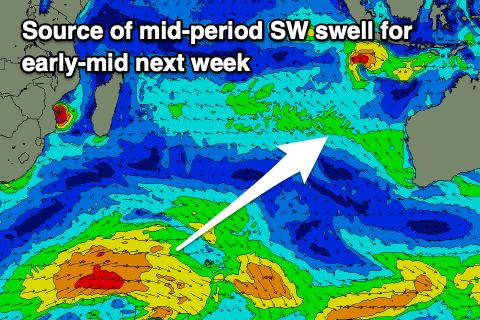
Coming back to the follow up swells and we’ve got a couple of healthy frontal systems for next week. The first will be a slow moving frontal progression that's currently to the south-east of South Africa. A moderate sized, mid-period SW swell is due next Tuesday from this source, peaking into the afternoon (earlier Mentawais), with a larger S/SW groundswell due into next Thursday from a stronger frontal progression firing up across the Heard Island region.

Those W/NW-W winds will favour selected spots again but only be moderate to fresh.
Looking at the Maldives, and we’ve got building levels of SE trade-swell across the region thanks to strong E/SE-SE winds feeding in on the southern flank of the monsoon trough.
These winds will persist but migrate slowly west over the coming week, swinging the swell direction more S/SE. Small to moderate levels of swell are due from this source, peaking later week but only easing slightly into the weekend.
This will be as new levels of S’ly swell arrive though, with the storm to the south-east of South Africa due to generate a moderate sized S’ly pulse for Sunday, peaking into the afternoon and then easing slowly Monday. A secondary, smaller pulse is then due mid-next week, ahead of a stronger pulse the following weekend. More on this Thursday though.
Eastern Indonesia:
Moderate to at times large levels of mid-period W’ly swell building this week (largest to the east), easing into the weekend and slowly through next week.
Moderate + sized, inconsistent S/SW groundswell building Thursday, reaching 6ft across exposed breaks late, easing from a similar size Friday morning.
Inconsistent, moderate sized mid-period SW swell building slowly Monday, peaking Tuesday afternoon to 4-5ft. Bigger S/SW groundswell likely next Thursday to 5-6ft.
Light to moderate N winds tomorrow, strengthening from the W/NW Thursday, persisting Friday and through the weekend, easing into next week.
Uluwatu 16-day Forecast Graph/WAMs
Western Indonesia/Mentawais/South Sumatra:
Moderate sized, junky mid-period SW swell today, easing slowly tomorrow with weak levels of W’ly windswell in the mix.
Moderate sized S’ly groundswell for Thursday afternoon, reaching 5-6ft across exposed breaks, easing Friday.
Inconsistent, moderate sized mid-period SW swell building Monday, peaking Tuesday to 4-5ft+. Slightly bigger S/SW groundswell likely next Thursday to 4-6ft.
Strong NW winds today (lighter to the north), similar tomorrow before easing slowly in strength Thursday, shifting W/NW-NW Friday and then weaker W/NW-NW Saturday/Sunday. More variable winds developing into next week.
Mentawai 16-day Forecast Graph/WAMs
Maldives:
Small to moderate sized SE trade-swell building, peaking later week to 3-4ft, easing slowly into the weekend.
Moderate sized S’ly swell building slowly Saturday but strongest Sunday, reaching 4-5ft across the southern atolls into the afternoon, easing slowly Monday.
Reinforcing S’ly swell for Wednesday to 3-4ft across the southern atolls, with a stronger swell likely the following weekend.
Variable NE winds tomorrow, lighter NW on Thursday/Friday. Moderate N’ly winds Saturday, shifting light N/NW Sunday and remaining light from the NE next week.


Comments
Latest notes are live.
Hi Craig
Thanks as always for the reports a question for you, there is a healthy system near Heard Island on the 18th, but it clashes with the nw coast WA cyclone on Thursday the 21st, as it travels up the coast. Would this interruption affect the expected size into Bali? For the 23rd?
Nah, the swells would travel right through each other.