Indonesia/Maldives forecast December 28
Indian Ocean Basin analysis by Craig Brokensha (issued Thursday 28th December)
This week through the following two weeks (Dec 29 - Jan 12)
Some fun, inconsistent groundswell seen through Tuesday and yesterday is now on the ease across the region, with smaller surf due into tomorrow and Saturday as unseasonal trade-winds persist.
Into Sunday, our inconsistent SW groundswell, mixed in with some mid-period S/SW energy on Monday are due, with the groundswell energy being very inconsistent in nature.
This is thanks to the storm generating it being in our far swell window, south of South Africa. The size looks to be just a touch under the swell see earlier this week, with the most size seen through Sunday afternoon/evening and Monday morning.
Following this the surf will back away in size, bottoming out into next Thursday/Friday.
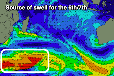
As touched on in Tuesday’s update, the longer-term outlook is much more interesting with a couple of strengthening storms to the south-east of South Africa due to generate a quality run of moderate to possibly large surf from the 6th of January through all of the following week.

The first frontal progression should generate a burst of W/SW gales and a moderate sized, inconsistent SW groundswell for Saturday, peaking later with a follow up swell for early in the week. More on this Tuesday.
Looking further west towards the Maldives and S’ly energy from yesterday is due to start easing through today, further tomorrow.
The E/NE windswell will persist over the coming days thanks to persistent, strong E/NE winds across the region, backing off into next week.
Smaller surf is due on Saturday out of the S’th ahead of the new S’ly generated by the strong low south of South Africa Sunday. A peak is due through the afternoon, moderate in size before starting to ease Monday.
Smaller surf is then due before a strong pulse of S’ly groundswell fills in Thursday, generated by the fetch of W’ly gales to the south-east of South Africa.
This looks to offer moderate + sized surf later Thursday, peaking Friday.
Small levels of SE trade-swell are also due to be in the mix next week and beyond but to no major size.
Winds will vary a lot thanks to a surface low forming west of the islands during early next week.
Eastern Indonesia:
Easing swell today and tomorrow.
Inconsistent SW groundswell building Sunday afternoon, reaching 4-5ft across the magnets, easing from a similar size Monday.
Moderate sized, inconsistent SW groundswell building Saturday (6th), reaching 4-5ft+ later, easing slowly from a similar size Sunday (7th).
Moderate E/SE-SE trades over the coming period, variable and locally offshore each morning.
Uluwatu 16-day Forecast Graph/WAMs
Western Indonesia/Mentawais/South Sumatra:
Easing swell over the coming days.
SW groundswell filling in Sunday, reaching 4-5ft on the magnets, easing Monday.
Moderate sized, inconsistent SW groundswell building Saturday (6th), reaching 4-5ft+ during the afternoon, easing slowly from a similar size Sunday (7th).
Variable winds this period, tending S/SE-SE across southern locations over the coming days, more variable from Sunday. Winds tending NW Monday and Tuesday next week.
Mentawai 16-day Forecast Graph/WAMs
Maldives:
E/NE windswell to 3ft+ across northern and central locations today, tomorrow and the weekend, easing slowly next week.
Easing mid-period S’ly swell from the 4ft range today.
Inconsistent S’ly groundswell for later Saturday, peaking Sunday to 4ft on the southern atolls. Easing swell into Monday.
Moderate + sized S’ly groundswell building Thursday, peaking Friday morning to 4-6ft across the southern atolls.
Stronger winds from E/NE across the northern and central atolls, weaker to the south today, tending S/SE tomorrow.
Winds shifting E/SE across northern and central locations Saturday/Sunday, S tending SW to the south.
E winds continuing across northern and central locations early next week, N/NW to the south, shifting SW during the middle of the week and SE across northern/central locations.


Comments
Latest notes are live.