Indonesia/Maldives forecast August 1st
Indian Ocean Basin analysis by Craig Brokensha (issued Tuesday 1st August)
This week through next week (Aug 2 - 11)
Building levels of S/SW groundswell are due through today, with the arrival now brought forward a little, with a strong spike due later in the day, peaking this evening and easing very slowly through tomorrow.
This should then be followed by a reinforcing pulse of S/SW energy Thursday afternoon. Both swells were generated by a strong polar frontal progression that then projected up and into Western Australia on the weekend, with the earlier stages generating a pulse of size today across the Maldives.

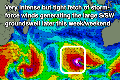
We then look at the large S/SW groundswell showing on the charts late week.
This swell has been and is still being generated by a significant but tricky low that developed between Heard Island and the Margaret River region yesterday.
There are a couple of things I like about this low, but also a few I don't.
The low was quite intense with storm-force S/SW winds at its core, aimed straight north towards Indonesia. The problem lies in the small, tight and short-lived nature of these winds, and the low is now broadening while weakening and moving slowly east.
We're looking at a large S/SW groundswell but these factors will likely limit it reaching any overly significant size, with a strong building trend due Friday afternoon, peaking into the evening and then easing fairly quickly Saturday.
The swell should also impact the Maldives late week, arriving and peaking around the same time.

Following this, a strong polar frontal progression forming east of the Heard Island region and to the south-west of Western Australia. should generate a moderate to large mix of S/SW groundswell and mid-period energy for Tuesday through Wednesday.
The polar front looks to form late in Indonesia's swell window, with mid-latitude frontal activity likely generating the most size though coming in with a bit less period.
Across the Maldives, building levels of SE trade-swell are due late week, generated by a great intensification of E/SE-SE winds through the Indian Ocean today and tomorrow, weakening slowly later in the week.
This will see the swell building Friday and peaking Saturday, easing thereafter into next week.
Eastern Indonesia:
Large, strong pulse of S/SW groundswell late today to 6ft+ across exposed breaks, easing from 6ft to occasionally 8ft tomorrow morning, smaller Thursday.
Large spike of S/SW groundswell building Friday, reaching 10ft across exposed breaks late, easing from a similar size Saturday morning.
Moderate to large mix of S/SW swells for Tuesday through Thursday next week to 6ft to occasionally 8ft.
Moderate SE trades for the coming days, freshening later week, though light and variable each morning. Moderate to fresh SE trades next week, light and variable each morning.
Uluwatu 16-day Forecast Graph/WAMs
Western Indonesia/Mentawais/South Sumatra:
Moderate to large S/SW groundswell arriving late today but peaking Wednesday/Thursday to 6ft across exposed breaks.
Large S'ly groundswell building late Friday, peaking Saturday to 8-10ft across exposed south facing breaks.
Moderate to large mix of mid-period and S/SW groundswell for Tuesday through Thursday to 6ft+ across exposed breaks.
Moderate to fresh S/SE-SE winds tomorrow, lighter in the morning and to the north, stronger S/SE-SE Thursday and Friday across southern locations, lighter and more variable to the north.
Weaker SE winds into the weekend, more variable to the north, strengthening from the S/SE to the south Sunday afternoon through next week across southern locations.
Mentawai 16-day Forecast Graph/WAMs
Maldives:
Slowly easing, moderate sized SE trade-swell over the coming days.
Moderate to large sized S'ly groundswell peaking today to 4-5ft+ across southern locations (smaller Male), easing tomorrow.
New episode of moderate sized + SE trade-swell building Friday, peaking Saturday to 6ft across southern locations (a touch smaller Male). Smaller S/SE groundswell in the mix Friday/Saturday.
Persistent W'ly winds across northern and central locations, tending W/SW over the coming days and W/NW over the weekend, freshening next week. SE winds across southern locations, tending more variable next week.


Comments
Latest notes are live.
Excellent notes as usual thanks Craig. So expect Saturday arvo to get smaller and less consistent?
Yep.
Padang Padang Comp Run...?
A bit of reading between the lines in there ;)
Craig I am off to Bali for the family holiday looks like plenty of swell are they lullish or wave after wave (crowd levels are bad so I am hoping there are plenty of waves coming through) swells?
The swell for Friday/Saturday should be fairly consistent, with next week's not too bad either.
Off topic but opening forecast for Tahiti comp looks dire…
Yeah a bit suss, will have a forecast Thursday.
My hypothesis is crowds thin markedly above 5ft…hopefully that hypothesis gets tested this weekend!
Agree. Was in bali 11-21 July. got a couple swells, very noticeably thinner above 5-6'