Indonesia/Maldives forecast July 27th
Indian Ocean Basin analysis by Craig Brokensha (issued Thursday 27th July)
This week through next week (Jul 28 – Aug 4)
The current, large groundswell energy is due to ease back across the Indonesian region and Maldives over the coming days, further into the weekend.
A small mid-period S/SW swell is due to stop the easing trend further into Monday, but we're more interested in the long-period and inconsistent S/SW groundswell for later Tuesday and more so Wednesday next week.
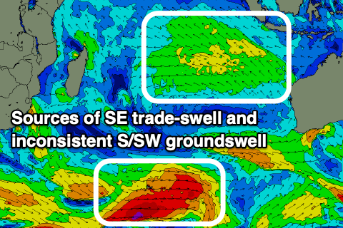
As touched on in Tuesday's update the source is a strong polar frontal system that developed south of South Africa earlier this week and is now in the Heard Island region while still generating a fetch of gale to severe-gale W'ly winds.

The frontal system will project towards Western Australia while weakening, followed by a final surge as a secondary intensification forms on its backside.
This will produce a couple of pulses of inconsistent S/SW groundswell which will prolong the event.
The models are incorrectly combining the new swells arrival on Tuesday afternoon, so don't expect too much size later, with Wednesday revealing the most size.
A slow easing trend is then due on Thursday.
The swell is expected to arrive in the Maldives early next week, peaking Tuesday.
The next episode of groundswell looks to develop into next weekend, that being a possible large to oversized S/SW groundswell from a significant storm forming to the south-west of Western Australia. More on this next Tuesday.
Coming back to the Maldives and moderate sized + pulses of SE trade-swell are due over the coming days, generated by an expansive fetch of strong E/SE winds through the Indian Ocean, currently at their strongest stage.
The fetch is due to break down slowly through the weekend and into early next week before being re-established mid-late next week. This will result in an easing trend from Sunday ahead of a renewal of swell later next week onwards.
Eastern Indonesia:
Easing S/SW groundswell over the coming days, 6ft to possibly 8ft early tomorrow but mostly 6ft+.
Small to moderate sized, background S/SW swell for Sunday afternoon and Monday, easing Tuesday.
Inconsistent, moderate to large S/SW groundswell arriving later Tuesday, peaking Wednesday to 6ft to occasionally 8ft across exposed breaks, easing slowly Thursday and Friday.
Possible larger S/SW groundswell for next weekend.
Moderate to fresh SE trades this week, weekend and early next week, weakening from Tuesday and possibly tending more S'ly on Thursday. Light, variable winds each morning.
Uluwatu 16-day Forecast Graph/WAMs
Western Indonesia/Mentawais/South Sumatra:
Easing S/SW groundswell tomorrow from 6ft+ across exposed breaks and further into the weekend.
Inconsistent, moderate to large S/SW groundswell arriving late Tuesday but peaking Wednesday/Thursday to 6ft across exposed breaks. Possibly larger S'ly groundswell next weekend.
Fresh to strong SE-S/SE winds this period across southern/eastern locations, light and more variable across northern locations, though freshening from Sunday through Monday here, becoming lighter again to the north from Tuesday.
Mentawai 16-day Forecast Graph/WAMs
Maldives:
Fading, small S'ly groundswell over the coming days.
Moderate sized + pulses of SE trade-swell building to 6ft tomorrow, holding Saturday (smaller Male), easing slowly from Sunday.
Moderate to large sized S'ly groundswell building later Monday, peaking next Tuesday, coming in at 4-5ft+ across the southern atolls (smaller Male).
New episode of moderate sized + SE trade-swell for late in the week onwards.
Light W winds to the north and E winds to the south tomorrow, similar Saturday but freshening from the W/NW to the north. Similar Sunday with moderate to fresh NW winds to the north.
W'ly winds to the north Monday with S/SE winds to the south, similar Tuesday/Wednesday but more S'ly to the south.


Comments
Latest update is live.
Wondering if anyone’s been to lakey p and can confirm if it sucks after Aug and/ or why ? Thinking of heading Sep but heard it’s windy af. Figured late season should be less trades and light winds so super confused…
Late season regarding winds would be from so November onwards IMO as the IOD signal if any reaches max strength through spring.
Yeh ok great to know. wonder if there could also be a SE sea breeze effect after august (Sumbawa’s coolest month) further accentuating the trades. Possibility maybe
Clay Marzo Shredding out Ulu this Morning .
The Boy is exited