Indonesia/Maldives forecast July 20th
Indian Ocean Basin analysis by Craig Brokensha (issued Thursday 20th July)
This week through next week (Jul 21 - 28)
Solid surf is breaking across all locations today but we've got our oversized, strongest pulse of SW groundswell due to arrive late, peaking tomorrow across Indonesia.
The source was a strong, northward protruding low into the Indian Ocean, generating fetches of gale to severe-gale winds.
This swell is due to hang around most of the day tomorrow, easing off later and further through the weekend.

A reinforcing pulse of moderate sized S/SW swell is due on Monday, generated by a strong and healthy frontal system that's currently south-west of Western Australia, then easing Tuesday.
The low point on Tuesday morning will be short-lived, with the next round of large, long-period SW groundswell due to fill in strongly Wednesday and hold Thursday.
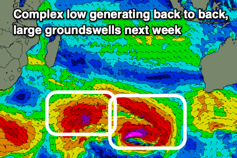
There'll actually be multiple pulses of swell thanks to a large, complex low forming around the Heard Island region today.
We'll see an initial fetch of pre-frontal gale to severe-gale W/NW winds with tighter severe-gale W'ly winds sitting just south, with a better aligned fetch of gale to severe-gale W/SW-SW winds pushing up on the backside of the low.

This will generate two distinct pulse of groundswell for next week, the first and smallest arriving late Tuesday, peaking Wednesday with a secondary larger pulse for Thursday morning.
Across western Indonesia this swell looks to arrive a touch earlier, kicking strongly Tuesday afternoon, with the secondary larger S/SW pulse for Wednesday afternoon, easing slowly Thursday.
The surf is due to continue easing into Friday and next weekend ahead of the next round of possible large surf early the following week (more on this next Tuesday).
The Maldives should be seeing a good pulse of S'ly groundswell today, though just under the size seen on Tuesday when the first, initial pulse peaked.
This swell is due to be overridden by a moderate sized+ SE trade-swell which will continue to muscle up through tomorrow and peak on Saturday before slowly easing Sunday but maintain plenty of size through early next week.
This is thanks to a broad, elongated fetch of strong E/SE winds through the Indian Ocean, with a slight weakening expected this weekend before restrengthening again next week.
The SE trade-swell should then kick back in size through mid-late next week.
The S'ly groundswell energy from the complex low is expected to arrive early next week as well, peaking Tuesday/Wednesday.
Eastern Indonesia:
Larg groundswell for Friday to the 8ft+ range across exposed breaks (10ft cleanups likely).
Moderate sized reinforcing S/SW swell Monday (24th) to 4-6ft, easing Tuesday morning.
Large SW groundswell showing late Tuesday, peaking Wednesday (26th) to 6-8ft.
Larger pulse for later Wednesday, peaking Thursday morning to 8ft+ (10ft cleanups likely).
Light winds tomorrow ahead of moderate to fresh E/SE trades on the weekend and into the middle of next week, tending SE later week. Variable winds each morning.
Uluwatu 16-day Forecast Graph/WAMs
Western Indonesia/Mentawais/South Sumatra:
Large S'ly groundswell for late Thursday, peaking Friday to 8ft+ across exposed breaks.
Easing swell through the weekend, further into early next week.
Inconsistent SW groundswell building Tuesday, reaching 6ft late with a larger S/SW groundswell Wednesday afternoon to 8ft+ across exposed breaks. Easing swell through the end of the week and weekend.
Fresh to strong SE-S/SE winds tomorrow, a bit weaker in northern locations, similar Saturday. More variable winds to the north Sunday, moderate to fresh S/SE to the south.
Persistent S/SE-SE winds next week, moderate to fresh in the south and lighter to the north Monday through Tuesday. Strengthening S/SE-SE winds from Wednesday through the end of the week.
Mentawai 16-day Forecast Graph/WAMs
Maldives:
S'ly groundswell peaking today to 4-5ft across the southern atolls (smaller Male).
Moderate sized + SE trade-swell building today and further Friday, peaking Saturday to 6ft+ across the southern atolls (smaller Male).
Swell easing slowly Sunday and further into early next week ahead of the next pulse mid-late week.
Inconsistent moderate to large sized S'ly groundswell building Monday (24th), peaking Tuesday (25th) to 4-6ft across the southern atolls (smaller Male), easing slowly Wednesday afternoon.
Fresh W/SW-SW winds across central and northern locations tomorrow, S-S/SE to the south.
Similar winds across central and northern locations Saturday, variable to the south, with weaker SW winds across central and northern locations Sunday, S/SE-S to the south.
Strengthening SE winds across southern locations next week with S/SW-SW winds to the north Monday, W'ly for the rest of the week.


Comments
Latest notes are live.
What the heck!
Made it...And how good would those fookin Croissants tasted
https://www.abc.net.au/news/2023-07-21/rob-barton-perth-man-rows-austral...