Indonesia/Maldives forecast July 13th
Indian Ocean Basin analysis by Craig Brokensha (issued Thursday 13th July)
This week through next week (Jul 14 - 21)
A strong, inconsistent S'ly groundswell should be building across the Indonesian archipelago this afternoon, with exposed breaks due to peak into this evening before starting to slow ease tomorrow, further through the weekend, ahead of a reinforcing pulse of mid-period S/SW swell on Sunday to the east.
This mid-period swell has been generated by a strong frontal progression currently pushing across Western Australia, with fun moderate + sized sets due, before easing into Monday.
A secondary, more distant pulse of background swell for Monday was generated a long way away and the models are incorrectly combining swell sources, over-forecasting the size. Exposed spots should still a little bump up from Sunday though.

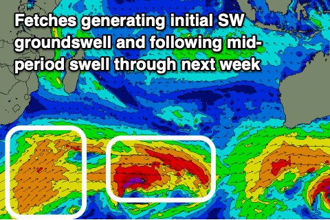
Of greater importance is a healthy frontal progression moving in from under South Africa and Madagascar, generating a fetch of gale to severe-gale W-W/NW winds followed by a broad fetch of strong W/SW winds.
This will then be followed by a stronger low, projecting north-east towards Indonesia on Sunday, breaking down slowly on approach to Western Australia through Monday/Tuesday.
What this will result in is various pulses of building swell through the middle to end of next week, the first being an inconsistent SW groundswell for Wednesday, followed by a fresh pulse of mid-period SW swell building Thursday afternoon and then final groundswell on Friday, peaking into the afternoon.

The swells will come in more south across western Indonesia along with a touch less size, while the Maldives will see plenty of size across exposed breaks through all of next week, starting from Monday.
Coming back to tomorrow, and easing levels of SE trade-swell will be seen across the Maldives, giving way to a fresh pulse of energy on Saturday, thanks to the general weakening of E/SE-SE winds through the northern Indian Ocean.
Strong levels of super-charged SE trade-swell are then due to develop from later week as high pressure establishes itself throughout the Indian Ocean, squeezed by increasing storm activity to the south. This will see an expansive fetch of strong E/SE winds aimed towards the north-west of the basin.
Eastern Indonesia:
Large S/SW groundswell building today, peaking later to 8ft+ across exposed breaks, easing from the 8ft range on the sets tomorrow morning.
Slow easing trend into Saturday and Sunday, with a moderate sized, reinforcing mid-period SW swell for Monday to 4-5ft+ across exposed breaks. Large SW groundswell for Wednesday, peaking to an inconsistent 6ft+.
Secondary pulse of mid-period S/SW swell building Thursday afternoon to 6-8ft with a larger groundswell for Friday to the 8ft+ range across exposed breaks.
Moderate to fresh SE trades tomorrow, weaker on the weekend. Variable winds early each morning. Stronger E/SE-SE trades moving in next week with variable winds each morning.
Uluwatu 16-day Forecast Graph/WAMs
Western Indonesia/Mentawais/South Sumatra:
Large S/SW groundswell peaking this afternoon to 6-8ft across exposed breaks.
Swell easing slowly through Friday and into the weekend. Moderate sized, inconsistent, background swell for Monday to 4-5ft.
Moderate to large S/SW groundswell building Wednesday, reaching 6ft+ across exposed breaks, with a larger mid-period swell for Thursday to 6ft to possibly 8ft. Large S'ly groundswell Friday to 8ft.
Fresh SE winds developing tomorrow, weaker on the weekend, with fresh SE-S/SE winds likely to develop through next week (lighter across more northern regions).
Mentawai 16-day Forecast Graph/WAMs
Maldives:
Easing SE trade-swell tomorrow from 3-4ft across the southern atolls, 3ft in Male. Smaller S'ly swell also easing.

New pulse of moderate sized SE trade-swell for Saturday to 4ft, easing Sunday (smaller Male).
Moderate to large sized S'ly groundswell building Monday afternoon, peaking Tuesday to 5-6ft across the southern atolls (smaller Male).
Secondary pulse of moderate to large sized S'ly groundswell for Wednesday to a similar size across the southern atolls.
Super-charged SE trade-swell building Friday, peaking next weekend.
Light to moderate W/SW winds tomorrow across the northern and central regions, lighter S/SE tending variable to the south.
Variable winds for the weekend (tending W/NW to the north) with a general W-SW flow through next week. Possible fresher S'ly winds across the southern atolls later in the week.


Comments
Latest forecast is live.
Thanks Craig, great to see this report back up.
Just out of interest, trying to gauge the reality of a 2.3m 15 sec swell at Ujung Bocur. Have been there before (and had it largish) but cant recall the conditions.
Dropping in on the 20th for 10 days and it looks like a couple of solid days over the period.....on the charts, so trying to arrange the quiver. :-)
Also, if any punters know of places apart from Krui, that may be manageable, if its bombing....would appreciate feedback :-)
Woot!! Go Indo !!
Thanks for these Craigos - much appreciated.
Which Swellnet forey region is the most relevant for the Banyaks? Guessing Nias or Simeulue?
Never been before but heading there next week!
Yep, both of those would cover the region, though expect less size from the south swells.
Cheers!
Let’s go!!!