Indonesia/Maldives forecast July 6th
Indian Ocean Basin analysis by Craig Brokensha (issued Thursday 6th July)
This week through next week/weekend (Jul 7 - 14)

Our large mix of building swells came in right on cue yesterday with the the Bukit building to a strong 6ft to occasionally 8ft through the afternoon. This morning the swell was holding the same size and we should see a larger, stronger pulse of S'y groundswell pulsing late today ahead of a peak tomorrow morning.
As touched on in Tuesday's forecast, the source was a severe, complex low sitting off Western Australia early in the week and we should see strong surf across all of Indonesia tomorrow, easing slowly into the weekend.
Sunday morning looks to be a temporary low point in activity ahead of an inconsistent, moderate to large long-period SW groundswell building into the afternoon, peaking Monday afternoon.
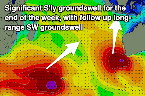
The source of this swell was a strong frontal progression firing up under South Africa, weakening while pushing east more into the Indian Ocean. The swell should arrive in western Indonesia earlier and through Saturday afternoon, peaking Sunday afternoon and easing slowly Monday.
There won't be much downtime between swells with a progression of strong mid-latitude fronts set to line up across the southern Indian Ocean from tomorrow but more so the weekend.
The first will generate a fetch of strong to gale-force W'ly winds will traversing east, followed by a stronger, more elongated fetch of severe-gale W/NW winds. There may even be bursts of storm-force winds embedded.
With the storm being strongest and more favourably aimed towards eastern locations, eastern Indonesia will see the largest surf, with a large, long-period S/SW groundswell due to arrive through next Thursday afternoon, peaking Friday morning.

For western Indonesia expect a later arrival and peak more so into Friday afternoon.
Looking at these swells for the Maldives and an initial peak in S'ly groundswell was due yesterday, easing today ahead of the S/SE groundswell from the low off Western Australia arriving later tomorrow, peaking Saturday.
At the same stage, the S/SW groundswell from under Madagascar is due to fill in Saturday, peaking through the afternoon and easing slowly Sunday.
A third swell source will be a moderate sized mid-period SE swell generated by a great fetch of strong SE winds that have developed to the south-east of the atolls.

All swells are due to start easing Sunday afternoon, further into early next week ahead of a small to moderate sized kick in mid-period S'ly swell Wednesday afternoon, generated by the first front in the progression moving through the southern Indian Ocean.
Fun levels of mid-period SE swell will persist at the same time thanks to persistent SE winds throughout the Indian Ocean aimed towards the Maldives.
Eastern Indonesia:
Large, long-period S'ly groundswell kicking later Thursday, peaking Friday with 10ft sets on the exposed breaks, easing into the afternoon and from 6-8ft Saturday. There's the chance for magnets to see some 12ft clean-ups at the peak of the swell so keep your eyes peeled.
Moderate to large, inconsistent SW groundswell building Sunday (9th), peaking Monday afternoon (10th) to 6ft to occasionally 8ft across exposed breaks.
Easing surf Tuesday and Wednesday ahead of a mix of large, long-period S/SW groundswells building Thursday, strongest late, peaking Friday morning to 8ft+ across exposed breaks.
Fresh and gusty E/SE-SE trades with periods of variable winds each morning.
Uluwatu 16-day Forecast Graph/WAMs
Western Indonesia/Mentawais/South Sumatra:
Larger, less consistent S'ly groundswell for late today, peaking Friday to 8ft on the exposed south facing breaks (possible bigger clean-up southern locations), easing through the late afternoon and Saturday.
Larger inconsistent SW groundswell building later Saturday (8th), more so Sunday (9th) reaching 6ft to possibly 8ft across exposed breaks into the afternoon, easing from a similar size Monday morning.
Large, long-period S/SW groundswell building later Thursday, peaking Friday to 6ft to occasionally 8ft.
Winds look generally E/SE tending S/SE across southern regions through tomorrow and the weekend, (fresh afternoons), with the pattern weakening and tending more variable next week. To the north lighter, variable winds are due the whole period.
Mentawai 16-day Forecast Graph/WAMs
Maldives:
Easing mix of S'ly groundswell and SE trade-swell today.
Secondary pulse of S'ly groundswell building later Friday (7th), peaking Saturday, mixed in with a moderate sized, S/SE groundswell and moderate sized SE trade-swell.
Surf building to the 6ft range Saturday, easing Sunday (smaller Male), easing further early next week.
SE trade-swell maintaining 4ft surf through most of next week (3-4ft Male).
Moderate sized mid-period S'ly swell building Wednesday afternoon reaching 3-4ft across the southern atolls, easing Thursday.
Weaker W/SW-SW winds across central and northern locations into the end of the week, variable to the south.
Light to moderate W-W/SW winds central and northern locations Saturday, W-W/NW Sunday. Variable to the south.
Fresher W'ly winds central and northern locations next week, lighter to the south and more variable.


Comments
Thursday's update!
Talk about Christmas in July!! Thanks for the updates Craig.
Its the dry season right? Ive been at Ulus for 3 days and its virtually has not stopped
raining day or night and predications are for another week. Whats going on.
Swell update at Ulus the swell was definitely bigger Thursday by a big margin.
Friday probably 6t Plus solid unbelievably inconsistent actually bigger last Wednesday scares the hell out of me when you say inconsistent for the next swell thats the problem over here its not the crowd its the inconsistence of the sets it sucks and the Brazzo clowns riding 9ft rhino chasers. Dead set wankers. Wish the sun would appear and stop raining but hey im not working and there are waves.
Interesting, thanks Evo.
Pretty spot on with your forecast Craig, today starting pulsing on the Bukit around 13:00 it seemed to be accompanied by a decent high tide which was keeping most punters honest.