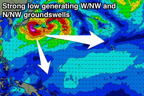
Strong swell for Micronesia and PNG
Hawaii North Shore, Micronesia and PNG forecast by Craig Brokensha (issued Tuesday 14th March)
Best Days: North Shore tomorrow, next Monday through Wednesday, Micronesia Saturday onwards, PNG Sunday onwards
This week and next (Mar 10 – 17)
Hawaii: A good pulse of new NW swell today with light winds, coming in mostly around 6ft on the sets.
We'll see this swell slowly tail off over the coming days with E/NE trades. Magnets should ease from 4-5ft on the sets tomorrow, smaller Wednesday and bottoming out Thursday afternoon.
Besides a small mid-period W/NW swell Friday there's nothing too major on the cards until early next week groundswell wise.
A small low forming to our north Thursday but quickly moving east will generate a short-lived fetch of N/NW winds on the edge of our northern swell window, generating a small swell pulse for later Friday and Saturday to 3ft to maybe 4ft, easing from a similar size Sunday morning.
E/NE trades over the coming days will tend more NE from Thursday and hold Friday before reverting back to the E/NE over the weekend.
Monday's W/NW groundswell will be produced off Honshu, Japan by a strong but distant low pressure system, aiming a fetch of severe-gale W'ly winds through our far western swell window.
Due to the west in the direction, this swell will perform better at some breaks compared to others, with a late increase Sunday ahead of a peak Monday to an inconsistent 4-5ft.
The swell should ease Tuesday, but a secondary re-intensification of the low should produce a slightly more NW pulse to 3-5ft Wednesday afternoon.
Beyond this there's nothing significant at all on the cards until the following week when a large NW groundswell may be seen, but more on this Thursday.
North Shore Forecast Graph
North Shore WAMs
Micronesia: We're currently seeing low surf across all breaks with a small easing N/NW groundswell across exposed reef passes and no E/NE trade-swell.
We should see the trade-swell slowly building again from Thursday as a weak and stationary fetch of trades develop east of us, extending under Hawaii, weakening a touch late week.
 Of greater importance is the N/NW groundswell due off the strong low forming off Honshu. This low has been delayed a little since last update, but strengthened and we should see a good large N/NW groundswell for the coming weekend.
The swell will arrive Saturday and building strongly to 6ft+ by dark, peaking early Sunday to 6ft to occasionally 8ft, down steadily from here.
Gusty E/NE trades are expected through this swell, remaining stiff through early next week, easing later.
Some smaller reinforcing N'ly swell is expected through the rest of the week with waves not dropping below 2-3ft as it bottoms out Wednesday and then kicks again Thursday.
Palikir Pass Forecast Graph
Palikir Pass WAMs
Papua New Guinea: There's nothing significant breaking on the coast at the moment with a small background mix of E/NE trade-swell and N/NW groundswell.
The surf will remain small to tiny until the N'ly groundswell builds Sunday and peaks Monday. We should see strong and inconsistent 3-4ft waves by later Sunday, with 3-5ft sets Monday morning, easing off into the afternoon and Tuesday.
The surf will then revert back to the small size range for the rest of the week.
Conditions will be great for this swell with variable winds from the E/SE.

