North Pacific slows down into the New Year
Hawaii North Shore forecast by Craig Brokensha (issued Thursday 22nd December)
Best Days: North Shore Tuesday, Wednesday and Thursday morning, Micronesia Thursday, PNG over the coming days before the swell becomes small
This week and next (Dec 22 – Dec 30)
Hawaii: Christmas Day's large pumping NW groundswell has eased back into this morning with 6-8ft waves across the North Shore.
Smaller surf was seen this afternoon and we'll see the swell bottom out tomorrow morning.
A reinforcing NW groundswell due tomorrow afternoon is still on track, generated on the backside of the low responsible for the weekend's swell.
Inconsistent 4-6ft sets are due into Tuesday afternoon, easing from 4-5ft+ Wednesday morning, smaller Thursday with fresh E/NE trades.
 Unfortunately there's no significant swells due out of the NW through the end of the week and next week as a large blocking high keeps moves slowly across our swell window to our north.
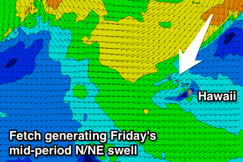
We should see another funky N/NE swell from a deep trough and cut-off low forming to our north-east.
An initial fetch of strong to gale-force NE winds will then be followed by a tighter and smaller fetch of E/NE gales through our northern swell window, producing a mid-period N/NE swell for Friday followed by N/NE groundswell over the weekend.
Exposed breaks to the north should come in around 6ft Friday with gusty NE winds, easing a touch Saturday then kicking again Sunday afternoon to 4-6ft easing Monday.
Winds will remain poor and from the NE Saturday, N/NE Sunday, weakening Monday before SE winds kick in Tuesday.
Besides some small background mid-period NW swell mid-late next week, there's still nothing significant on the cards until January 8/9th, but more on this Thursday.
North Shore Forecast Graph
North Shore WAMs
Micronesia: Easing trade-swell out of the E/NE currently, dropping off further through the week and bottoming out Saturday.
The trades should ease off later tomorrow and become variable Thursday before kicking up again Friday.
Into Sunday a small lift in N/NW groundswell is expected from a low pushing off Japan, but without any strength in the fetch aimed towards us, or longevity no major size is due.
Exposed breaks are due to build to an inconsistent 3ft+ later Sunday, peaking Monday to 3-4ft and then easing back Tuesday.
For the rest of the week a small mix of N/NW and E/NE swell are due but to no major size.
Palikir Pass Forecast Graph
Palikir Pass WAMs
Papua New Guinea: The good NE swell currently impacting the coast should hold tomorrow before easing Thursday from 3-4ft+, smaller into the weekend.
The N/NW swell impacting Micronesia probably won't offer much in the way of size with a very inconsistent 2ft+ wave due Monday and Tuesday, but background levels of E/NE trade-swell will come in around a similar size.
Longer term the trade-winds are expected to really kick up through our swell window at all over the coming couple of weeks, so it's going to be a slow period.

