Easing surf ahead of messy N/NW swell developing Sunday
Hawaii North Shore forecast by Craig Brokensha (issued Tuesday 16th February)
Best Days: Tuesday through Thursday morning, Saturday morning, later Tuesday next week
This week and next (Feb 9 - 19)
 A very late kick in W/NW groundswell Sunday, peaked through today with good and fresh E/NE trades.
This swell has eased off at the 51101 buoy approximately 10 hours travel time to our north-west, but a local late kick in swell on the Waimea 51201 buoy this afternoon is localised windswell.
We should see our current groundswell easing back through tomorrow from the 6-8ft range across exposed breaks tomorrow with stronger E/NE trades, tending NE into the afternoon
Stiff and unfavourable E/NE trades will continue through Wednesday and Thursday as the swell continues to ease and bottoms out Friday morning. There's nothing significant due through the weekend either with a background pulse of NW groundswell Saturday morning to 4-5ft or so.
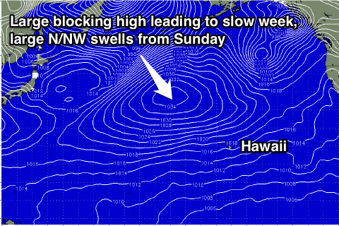
This lack of swell will be linked to a large blocking high dominating our swell window for all of this week, but this is forecast to break down through the weekend as a vigorous storm forming south-east of the Kamchatka Peninsula projects south-east down towards us.
This storm should produce an initial fetch of severe-gale W/NW winds in our far north-western swell window before moving more into our northern swell window as it projects south-east towards us.
An XL swell should result, but a secondary strong front pushing down into the islands along with the swell on Sunday will add a short-range N/NW swell also to the mix.
Both swells are due to build strongly through Sunday afternoon, reaching 12-15ft by late, easing from the 15ft range Monday morning, further down from 12ft+ Tuesday morning.
Conditions are unfortunately looking average as the front pushes down into us bringing strengthening NW tending N'ky winds Sunday and N/NE winds Monday, becoming lighter from the NE into Tuesday.
Longer term we may see an even bigger and broader low forming off the Aleutian Islands through next week generating an XXL swell for Thursday/Friday but check back here Thursday for an update on this.


Comments
Geez the swell for Friday 26th looks massive - favourably light winds too. Will Eddie go...?
It's an absolute monster and consistent! Winds are the main issue with the storm pushing so close towards the islands. Keep an eye out for the forecast update this arvo.