Easing XL swell ahead of XXL swell Wednesday
Hawaii North Shore forecast by Craig Brokensha (issued Tuesday 26th January)
Best Days: Every day over the coming period for only the most experienced surfers
This week and weekend (Jan 27 - 31)
Easing surf was seen late last week and into the weekend, ahead of a large XL kick in NW groundswell yesterday afternoon, followed by a secondary larger kick this afternoon.
These swells were generated by a multi-staged frontal progression moving in from the west over the weekend, but this has since dispersed, with easing levels of NW groundswell due into tomorrow, bottoming out dawn Wednesday.
 The 51101 buoy about 500kms north-west of Hawaii is still holding in the XL range, but should start to ease from now, and with a 10 hour lag, tomorrow morning should still see 15ft+ sets easing back steadily through the day. Light variable winds are expected during the morning creating clean conditions ahead of afternoon sea breezes.
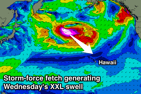
As talked about last week, an even larger XXL swell event is due into Wednesday across the islands generated by a vigorous frontal progression firing up under a strong node (peak) of the Long Wave Trough.
Satellite observations (right) have already picked up a broad fetch of storm-force 50-60kt W/NW winds aimed towards Hawaii, with the progression expected to push south-east while weakening slowly over the coming 24 hours.
A very strong long-period XXL swell will be generated by this system, but it's not quite as vast or as expansive as forecast late last week.
 In saying this we should see the fore-runners in the 22s range arrive dawn Wednesday morning, with the bulk of the swell not too far behind, building rapidly through the morning to 20-25ft across selected breaks into the afternoon/evening, peaking overnight and then easing from the 15-20ft range Thursday morning.
Expect larger sets at deepwater offshore reefs.
Conditions are looking great with light morning land breezes and weak afternoon sea breezes through both Wednesday and Thursday.
The swell should continue to ease from the 10ft range Friday, further down into Saturday and Sunday as the E/NE trades kick in.
Longer term a large NW groundswell is on the cards for next Monday from a much weaker but broad storm developing to our north-west over the weekend, but more on this Thursday.


Comments
Hey craig, on the surf forecast it goes from 0.5ft to 20-25ft within 6 hours. Computer glitch perhaps?
Yeah that's a glitch in the wave model (not our internal system, the NOAA WW3 model).
51101 buoy looking incredible. Should be a a great day of big waves ahead!
Just got in from Waimea, it got big pretty quick. Some big chunks moving through. Very tricky conditions even though it looks clean, there should be some hefty wipeouts today. Alot of crazy's out there. Glad I got in in one piece, beer o'clock I reckon.
Unreal FL, thanks for the feedback. What time did the swell really start to kick?
The first big set came in about 1030 1100. Must have been the start with quite a few big names heading out.
Yeah have a look at this J-curve! Would of gone from go to woe in an hour or so!
Waimea Buoy..
Although the term is technically "go to whoa", I think your interpretation of "go to woe" is probably appropriate at maxing Waimea.
FL, your obs fit in well with the Waimea buoy obs - leading edge in around 8am (well, technically between 7:30-8am), a moderate kick in size between 9-10am, then a major kick in size from 11am onwards.
Shane Dorain at Peahi, about 30 mins ago.
Bloody hell!
And apparently this was JOB's first wave, about an hour ago.
Yeeha!
Near close-out at Waimea?
Yep, closing out the Bay.
wow, maybe they were too premature cancelling the Eddie?
As with most events of this nature (XXL) '"not the required 8 hours of 20ft+ surf." Jeez you'd have to get lucky to see a whole day in that upper range..
From Kelly..
Looks like Pat Caldwells initial call was correct.
Fauntleroy magillacutter surfs da bay then drinks beer . I think I have found out who u are , something about the name I knew from wayback . If it was you who surfed haleiwa yesterday ? Well done , is that you ?
Albee Layer on a mental drop!
Via instagram Albee,s telling Laurie Towner come on over and surf Jaws
Lauries reply its doing my head in seeing all these swells and not being able to get there due to coin and family commitments.........!
Many other surfers would pull the I cant make it "im injured card" - but not Laurie !
No shortage of size either.
You could be onto something caml....haha
Enjoy the beers and viewing spectacle u have earned it
How's the left!
Luke Shepardson on a bomb at Waimea.
How's the offshores blowing up the face!
That is incredible!!
Comments are now being directed into the new forecast thread: https://www.swellnet.com/reports/forecaster-notes/hawaii/2016/01/26/easing-xl-swell-ahead-xxl-swell-wednesday