Back to back XL swells expected
Hawaii North Shore forecast by Craig Brokensha (issued Tuesday 19th January)
Best Days: Tuesday, selected breaks that handle the wind Wednesday, Thursday experienced surfers, Friday morning, Sunday onwards experienced surfers only
This week and next (Jan 20 - 29)
Well what a couple of days of epic waves on Friday and Saturday. The largest swell of the season (forecast and discussed here) made landfall on Friday and provided some of the biggest paddle waves seen to date at Peahi, with large close-out sets also rolling through Waimea Bay.
A peak was seen through the afternoon/evening across the North Shore, while Saturday morning still offered XL and easing 15-20ft sets.
Since then the swell had steadily dropped away, stopped by a reinforcing NW groundswell Sunday afternoon and then moderate N/NW groundswell for this afternoon in the 6ft to occasionally 8ft range.
 This afternoon's moderate sized N/NW groundswell is expected to ease back through tomorrow from 6ft+ during the morning with light variable winds and weak afternoon sea breezes.
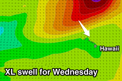
A late kick in new mid-period N/NW groundswell is expected, but of greater importance is a new XL swell event for Wednesday.
Currently a strong low pressure system is positioned to our north-west, generating a fetch of severe-gale to storm-force W/NW winds (pictured right). The low will project south-east past the Date Line while continuing to generate winds in the severe-gale to storm-force range.
A large long-period swell will result, building rapidly through Wednesday and reaching 15-20ft into the afternoon across the North Shore. A steady drop in size is expected Thursday from the 12-15ft range early, down to 8-10ft into the afternoon and further down from 4-5ft Friday morning.

Conditions are looking dicey Friday as the XL swell fills in with moderate N'ly winds, freshening from the N/NE through the afternoon, while a return to E/NE trades is due Thursday, weaker into Friday.
The swell will bottom out over the weekend, but from Sunday afternoon we're set to see a series of XL swells impacting the Hawaiian Islands.
These swells will be related to a series of broad and vigorous storms firing up off of Japan and moving east through the North Pacific Ocean towards Hawaii.
The first system will be a very broad, expansive and slow moving progression resulting in a sustained period of XL surf from later Sunday through early Tuesday, peaking Monday in the 15-20ft range.
Behind this though a more vigorous and faster tracking frontal progression looks to generate a similar sized N/NW groundswell for Wednesday afternoon/evening, but we'll have a closer look at both these swells on Thursday as well as the local winds (which look variable at this stage).


Comments
It looks like the North Pacific is really starting to hit its straps. Have a quick play of the WAMs
I wonder if the Eddie organizers would consider extending the waiting period into the first week of Feb.? That (still hypothetical) purple blob at the end of the model run looks nuts!
Craig - your forecasting has been spot on over the last few weeks, including the little ups and downs in swell during the day. Have been on the outer islands dodging bombs. Keep the great updates coming!!
Thanks for the feedback Muffsic, great to hear!
How are the Waimea buoy readings this afternoon!
18ft @ 18s!!