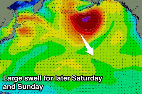
Slow end to the week, large swell for the weekend
Hawaii North Shore forecast by Craig Brokensha (issued Tuesday 24th November)
Best Days: Thursday onwards (experienced surfers only later Saturday, Sunday and Monday)
This week and next (Nov 25 – Dec 4)
After some good waves late last week, the swell has really backed off with small surf best suited to swell magnets.
A new kick in swell due Thursday is still on the cards, with the secondary pulse for Friday being downgraded a little from the last update. The source of this swell was a really strong but distant low forming off of Japan and pushing towards the Aleutians, with inconsistent but strong long-period sets to 4-5ft+ at swell magnets and more in the 5-6ft range Friday.
Strengthening E/NE trades will develop from Wednesday and then ease back a touch through the weekend and early next week.
Now, our large pulses of NW groundswell mentioned in the last update for this coming weekend have shifted around a bit regarding how they form and also the timing.
Typhoon In-Fa is still lingering east of Taiwan and south of Japan, taking a little longer than forecast to track north-east and be absorbed into the North Pacific storm track.
 The low that was expected to dragged behind it once it moved further north, is now due to push off the Japanese coast first, aiming a small but very intense fetch of severe-gale to storm-force NW winds towards Hawaii through the second half of this week, stalling off the Aleutians Friday will weakening and broadening a touch.
What this should result in is a large long-period kick in NW groundswell later Saturday, peaking from the N/NW Sunday. The North Shore should kick to 8-10ft by dark Saturday, with Sunday morning seeing easy 10-12ft+ sets.
The N/NW swell will then only fade really slowly, due to the stalling nature of the low, with Monday morning expected to still see 10ft sets.
A more significant drop is then due into the afternoon and further Tuesday.
The next pulse of swell is due Wednesday and this will be a touch under Sunday's swell, generated as the weak remnants of Typhoon In-Fa and a stronger low forming off Japan take a similar path to the system before.
Core wind speeds and the scope of this second low looks to be a touch smaller and weaker, with the swell from it due to come in more around the 10ft range. We'll have a closer look at this on Thursday though.


Comments
Just want to say thanks for providing a surf forecast with a scale I can understand.
Eg, for wed 2 Dec: "10-12 foot sets".
Surfline on the other hand, for wed 2 Dec: "23-27 feet, 6x overhead".
No worries Rusty, yeah the lastest updates have Wednesday's swell going large now, 12-15ft.