Fading surf ahead of large swells next weekend
Hawaii North Shore forecast by Craig Brokensha (issued Thu 19th November)
Best Days: Thursday, Friday morning, next Thursday onwards
This week and next (Nov 19 - 27)
Welcome to the first Hawaii forecast of the season, and while theres nothing too significant at all on the cards after today's building swell, the longer term charts are looking to light up.
Today a good moderate sized NW groundswell has filled in with it due to peak this evening to 6-8ft+ across the North Shore before tailing off from 6ft to possibly 8ft early tomorrow.
From here there's nothing significant on the cards with the swell backing away through the weekend while tending more N'ly under fresh to strong but easing E/SE winds, tending more S'ly into Saturday and then variable Sunday/Monday.
Size wise we'll probably see exposed spots hovering around 3ft from Sunday through Tuesday next week, ahead of a small kick in NW groundswell Thursday and then slightly bigger N/NW swell Friday afternoon.
The source of these swells will be firstly an intense but small low firing up off the Kamchatka Peninsula this Sunday, aiming a short-lived burst of severe-gale to storm-force W/NW winds through our swell window.
The distant and short-lived nature of the low will produce an inconsistent and smallish NW groundswell, possibly showing late Wednesday and building through Thursday to 4-6ft at swell magnets.
The swell should hold into Friday morning, as the low starts to broaden and weaken while continuing to aim NW winds towards us. The low is then forecast to track south-east closer to Hawaii, generating a more consistent N/NW swell for Friday, building to the 6-8ft range into the afternoon. As these swells fill in, stronger NE trades are due to develop, possibly backing off again into the weekend.
 Next weekend onwards (Nov 28 onwards)
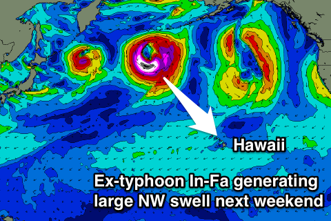
Now, as touched on at the start, the longer term charts are looking quite impressive as Typhoon In-Fa, currently well north of PNG and approaching the Marianas, due to do the usually drive-by Japan before being absorbed into the North Pacific storm track.
As the storm is absorbed just east of Japan, the ex-Typhoon will deepen significantly, aiming a small fetch of storm to hurricane-force W/NW winds through Hawaii's north-western swell window while staying west of the International Dateline. A large to possibly XL swell is expected off this system, kicking strongly Saturday afternoon before peaking Sunday morning in the 15-18ft range at this stage.
We may see a secondary low dragged into the storm track off of Japan behind ex-typhoon In-Fa, generating a more expansive fetch of NW gales closer to Hawaii later next week, producing a secondary large pulse for later Sunday/Monday the 29/30th but we'll have a closer look at this on Tuesday.


Comments
Typhoon In-Fa? Contender for most bizarre weather moniker of all time.