Fading swell, flat over the weekend, new swell for Tuesday
Hawaii North Shore forecast by Craig Brokensha (issued Wed 25th February)
Best Days: Thursday before the swell disappears, later Monday, Tuesday and Wednesday at spots that handle the NE wind
This week and weekend (Feb 26 – Mar 1)
A small kick in W/NW groundswell was seen through yesterday, with it holding into today, but its acute W'ly nature has resulted in less size than expected with inconsistent 3-5ft sets at exposed breaks across the North Shore. Conditions are excellent though with moderate to fresh E'ly trades.
Unfortunately we've got a slow forecast period ahead with the swell due to drop through tomorrow and become very small Friday, bottoming out through the weekend as strong NE winds develop. Therefore make the most of today's and early tomorrow's waves.
 Next Monday onwards (Mar 2 onwards)
Our next pulse of swell should arrive later Monday from the N/NW, and peak Tuesday in the 6ft range, produced by a small but favourably tracking low projecting down from the Aleutians over the weekend.
Unfortunately fresh to strong NE winds will limit surfing options both Monday, Tuesday and Wednesday, with poorer N/NE winds on the cards for Thursday.
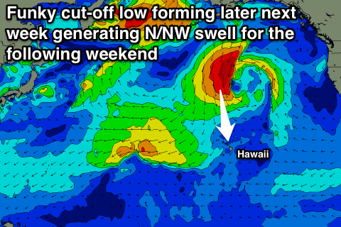
Longer term we're looking at a funky cut-off low forming to our north later next week, strengthening while stalling and aiming a fetch of N'ly gales towards us. With this we're likely to see a moderate to large sized N'ly swell developing sometime next weekend as winds become more variable. Check back here on Tuesday for the latest update on this development though.

