Couple of large swells, best Monday and Tuesday
Hawaii North Shore forecast by Craig Brokensha (issued Wed 11th February)
Best Days: Improving waves for experienced surfers tomorrow, breaks that like Kona winds Friday, Monday, Tuesday
This week and weekend (Feb 12 - 15)
Our current large stormy NW swells will start to ease through tomorrow and further into the weekend as the near stationary low sitting to our north, directing front after front into us slowly moves off to the north-east.
The North Shore is still expected to offer large easing 15ft surf tomorrow, down further from 8-10ft Friday before bottoming out Saturday morning.
Winds tomorrow should become variable from the E/NE resulting in the surf cleaning up while an approaching cold front Friday will bring poor and strengthen S/SW tending SW winds.
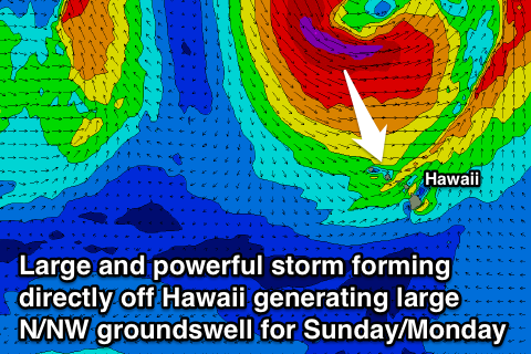
 During Saturday the frontal system is expected to become part of a much larger and stronger storm developing to our north-northwest with a fetch of severe-gale to storm-force N/NW winds being aimed at us right on our doorstep.
With this, Saturday will see winds become even poorer and strong from the W/SW to W/NW and then onshore from the NW to N/NE Sunday as a large N/NW groundswell pushes into the coast.
We should see the North Shore kicking in size rapidly to the 15ft+ range by the evening Sunday with 20ft sets likely at offshore reefs by dark.
Next week onwards (Feb 16 onwards)
The backside of Sunday's oversized N/NW groundswell will be the best time to surf as winds swung offshore from the E/SE from Monday with the swell easing from 12-15ft early, down to 8-10ft through the day before easing further from the 6ft range Tuesday morning.
Looking into the rest of next week and there's nothing too major on the cards besides a moderate to possible large sized long-range W/NW groundswell. We'll have a closer look at this on Tuesday though.

