Large surf all week, possibly bigger next week
Hawaii North Shore forecast by Craig Brokensha (issued Mon 12th December)
Best Days: Every morning over the coming period for experienced surfers
 This week and weekend (Jan 13 - 18)
Saturday's good and pumping pulse of NW groundswell eased through yesterday and has backed off further into this morning, but the first of a series of larger and powerful groundswells are due into this afternoon and evening.
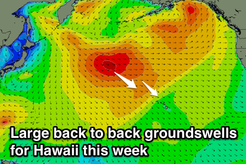
These groundswell pulses will be related to a broad Aleutian Low developing across the Northern Pacific, with a series of smaller embedded lows spinning anti-clockwise around its centre.
One of these lows has already set in motion a large NW groundswell for this evening, peaking tomorrow morning, with larger follow up W/NW groundswells due into Thursday/Friday and Saturday from broad busts of W/NW gales over the coming days.
The best thing about these Aleutian Low setups is that each frontal system is moving in quickly behind the one before it, passing over an already active sea state. This means the following storm needs to exert less energy to produce larger open ocean swells, and this will be the case over the coming week.
This evening's pulse should peak tomorrow morning in the 10ft+ range across the North Shore with 12ft bombs at offshore reefs before easing into the afternoon and further into Wednesday.
A low point in swell activity is due overnight Wednesday before the first pulse of large W/NW groundswell fills in strongly during the day, reaching 10-12ft into the evening across the North Shore. A slight drop in size is due through Friday, ahead of a possible late increase in new NW groundswell that's expected to peak Saturday in the 12ft+ range with 15ft sets at outer reefs.
Conditions are now looking better than they were last week with weak S'ly winds and afternoon sea breezes due through until Friday when winds should become more variable. Come the weekend weak trades should start to kick in for Saturday's large NW groundswell, persisting into next week as the swell backs away steadily.
Next week onwards (Jan 19 onwards)
As touched on above, the weekend's large NW groundswell is due to back away gradually into the start of next week, but signs are positive for an oversized W/NW groundswell through the middle of the week.
This will be linked to a very deep and powerful low forming off and just east of Japan over the weekend, projecting a fetch of severe-gale to storm-force W/NW winds towards us.
At this early stage we're probably looking at a large long-period swell in the 15-18ft range, but more on this in Thursday's update.

