Large easing swells, new large NW groundswell Saturday/Sunday
 Hawaii North Shore forecast by Craig Brokensha (issued Wed 10th December)
Best Days: Thursday afternoon, Friday, Saturday onwards
This week through Monday (Dec 12 - 15)
Today a very large and powerful NW groundswell filled in across the North Shore maxing out Pipe but opening up deep water reefs for business as well as seeing Jaws breaking perfectly for the second day running.
This NW groundswell should peak overnight and then ease slowly through tomorrow down from the 15ft range across swell magnets on the North Shore early and then further down through Friday from the 8-10ft range.
Conditions will improve through tomorrow after today's N'ly winds across the North Shore with fresh to strong E/NE trades kicking in through tomorrow and easing later before becoming more variable into Friday morning. This will be the pick of the current swell episode with clean large waves across the North Shore.

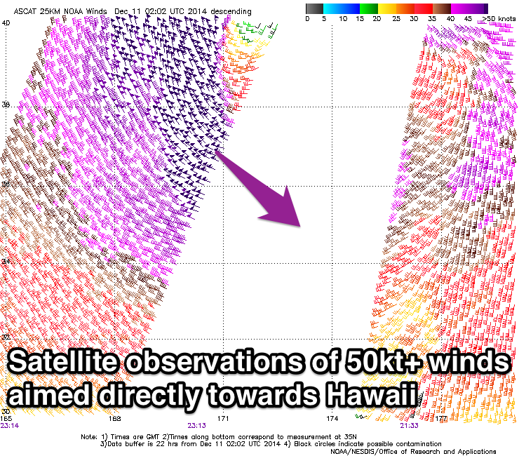
Our large and powerful long-period NW groundswell due to fill in rapidly Saturday is still on track with the 'bombing low' forming to the north-west of Hawaii forming as forecasts. Satellite observations have confirmed a fetch of storm to hurricane-force NW winds being aimed towards the islands and while the low will weaken while tracking east over the coming days, it will continue to aim a fetch of severe-gale to storm-force N/NW winds towards Hawaii with one final push down towards us during Friday, prolonging the longevity of the large swell.
As touched on last update, early Saturday will be a low point before the new swell kicks, but come midday the fore-runners of the NW groundswell should be kicking strongly with sets rising rapidly through the afternoon to 10-12ft+ by dark across the North Shore.
A peak is due overnight but Sunday morning should still reveal 10-12ft+ sets from a more northerly direction ahead of a slow easing trend through the day. Monday will then see a more pronounced drop in size from 6-8ft or so.
Winds are still expected to strengthen from the E/NE from Saturday and persist into Monday before easing off slowly through the middle of the week.
Tuesday onwards (Dec 16 onwards)
There's nothing significant on the cards for next week besides a small increase in NW groundswell Wednesday afternoon and then slightly bigger increase later Thursday and Friday morning.
Size wise we're only looking at inconsistent waves to 6ft+ on the sets at exposed breaks at the peak of the swell.
Longer term out XXL swell for the 21st of December is still on track with a very intense and broad low 'bombing' off Japan expected to traverse east through the North Pacific Ocean mid-late next week. We'll discuss this in greater detail over coming articles and updates though.


Comments
Latest Hawaii forecast update above.
Gee if current forecasts come to fruition will there be an Eddie swell 21st/22nd?
What winds are good for Waimea?
Yep, here it is Don.. https://www.swellnet.com/news/swellnet-analysis/2014/12/12/gifts-are-piling-xxl-swells-eddie-and-mavericks
Anyone got any opinions on the commencement of Pipe ?
Yeah they should run tomorrow morning (Friday Hawaii time), pumping clean easing 8ft or so Pipe. Might run early Saturday before a strong NW groundswell fills in.
The I'd say lay day Sunday with a large easing swell and back on again Monday.
Great work Craig, cheers mate.
I'd say that's Saturday sorted. Actually hoping the surf is shit. Is that bad ?
I'm still shit off they haven't finished the trials!!! Just wasting time for the main event in good surf now IMO. Which for me, will favour Gabby. The smaller the better chances he's got IMO.
Although with the swell smaller, will this also favour backdoor options which would favour Mick's chances then too?