Good S/SW groundswells from Thursday, with N'ly swells for the North Coast
Fiji forecast by Craig Brokensha (issued Sunday 6th March)
Best Days: Coral Coast Thursday onwards, North Coast tomorrow and then the weekend onwards
This week and next (Mar 7 - 18)
Coral Coast: The Coral Coast isn't expected to see much size at all over the coming period until later in the week. Exposed breaks are due to hover around the inconsistent 2-3ft range, strongest Tuesday and more in that upper 3ft range.
 Weak E/SE trades are due tomorrow and Tuesday, freshening a touch through Wednesday before easing back slowly through the end of the weekend.
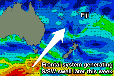
From Thursday through the weekend and Monday the following week, a couple of good but inconsistent pulses of S/SW groundswell are due across the islands.
The first for Thursday and Friday has been generated by a strengthening polar front pushing through the Southern Ocean and under Tasmania the last couple of days.
The swell should build through Thursday and reach an inconsistent 4-5ft across swell magnets like Cloudbreak during the afternoon, and then ease back from 3-5ft Friday morning. Frigates should offer the odd bigger set through the peak of the swell.
The next swell due to build through Saturday afternoon will be less consistent, generated in our far swell window, south of WA and south-west of Tassie but a slightly stronger and more persistent fetch of W'ly gales moving slowly along the polar shelf.
Due to the large distance between the source of the swell and our region, we'll see the size of the swell arrive some-time behind the initial 18s fore-runners through Friday, building Saturday to 4-5ft+ later in the day.
A slight re-intensification of the swell producing polar front while passing the entrance to the southern Tasman Sea through Tuesday should slow the easing trend Sunday and provide more consistent sets in the 4-5ft range, down from 4ft or so Monday.
More variable breezes are due over the weekend and early next week before E/SE trades kick in again from Wednesday.
Longer term, an inconsistent and small to moderate long-period groundswell is due later next week from an intense but short-lived polar low firing up under Australia. We'll have another look at this in the next update.
North Coast: A new long-range N'ly groundswell from the North Pacific is expected to build through this afternoon, peak overnight and ease back from an inconsistent 5-6ft tomorrow morning, further down through Tuesday and Wednesday morning.
 Besides a very inconsistent and small long-period N/NW groundswell Wednesday afternoon and Thursday morning there's nothing significant due until the weekend.
Fresh and gusty E/SE trades are due all weekend, strengthening into Thursday and Friday as a weak tropical depression starts to deepen to our south-west.
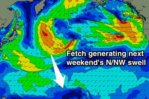
Into the weekend, a new inconsistent N'ly groundswell is due, generated by a relatively weak but broad and favourably aligned fetch of strong to gale-force N/NW winds developing in the North West Pacific. This fetch will project south-southeast towards us before pushing east towards Hawaii on Tuesday.
A slow increase in size should be seen through Saturday to an inconsistent 3ft across exposed breaks later in the day, peaking Sunday to 3-4ft+. A drop in size is then expected Monday as some new N/NE swell fills in produced by a healthy and broad fetch of E/NE trades establishing north of the equator through later this week. More on this in the next update though.

