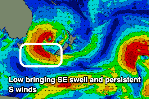
Tons of south swell, large from the south-east on the weekend
Eastern Tasmanian Surf Forecast by Craig Brokensha (issued Monday June 10th)
Best Days: Today, Wednesday afternoon, Thursday morning, protected spots later Saturday but more so Sunday onwards
Features of the Forecast (tl;dr)
- Building mid-period S'ly swell Wed with strong SW-W/SW winds, easing later
- Easing S swell Thu with W/SW tending S winds
- Building S windswell Fri with strengthening S/SW tending S winds
- Moderate sized S/SE swell building Sat with strong S/SW winds
- Large SE groundswell Sun with strong S/SW winds
- Slowly easing levels of SE swell next week with S/SW winds Mon/Tue
Recap
Fun levels of E’ly swell with morning offshores created good surf on the weekend, coming in at 2-3ft Saturday, smaller and to 2ft yesterday.
Today we’ve still got 2ft+ of swell in the mix with great conditions.
This week and weekend (Jun 11 - 16)
We’ve got another dynamic week and weekend of large surf ahead, as a strong polar front pushing up and across us on Wednesday, merges with instability following a mid-latitude low, and spawning a low pressure system just east of us.
Firstly, the polar front will bring a strong S/SW change Wednesday and with it, a moderate + sized pulse of mid-period S’ly swell is due.
Building surf to 4-6ft is likely across south magnets later along with strong SW winds, possibly tending W/SW later.
The swell will ease back quickly Thursday from 4-5ft across the south magnets along with W/SW tending S winds.
From Friday, we’ll see strengthening S’ly winds east of us as the low pressure centre starts to deepen.
This will initially generate some weak, building S’ly windswell, growing in period and tending more S/SE in direction on the weekend as the fetch starts to strengthen Friday.

The models diverge a little regarding the peak intensity of this low, but we are looking at a fetch of gales projecting from New Zealand’s South Island towards us Friday evening and Saturday, generating a significant, large SE groundswell for Sunday.
Size wise we’re probably looking at surf in the 8ft range at least and with strong S/SW-S winds the whole swell event.
The easing trend looks slow thanks to the stationary and persistent nature of the low. This points to fun SE swell all next week but check back Wednesday for the latest.

