Small east swell for the weekend followed by south
Eastern Tasmanian Surf Forecast by Craig Brokensha (issued Friday June 7th)
Best Days: Today, tomorrow morning, Wednesday afternoon and Thursday morning
Features of the Forecast (tl;dr)
- Small E swell tomorrow with W tending S/SE winds, easing Sun with similar but stronger winds
- Large mid-period S swell building Wed with strong SW winds, easing
- Easing S swell Thu with W-W/SW tending S/SE winds
Recap
A small signal of E/NE swell yesterday has built a little more into today, spreading out from an infeed of E/NE winds on the backside of the strong low linked to the large swell earlier in the week.
This weekend and next week (Jun 8 - 14)
The coming weekend should see small levels of E/SE swell across exposed beaches, spreading off a fetch of strong SE winds feeding into the southern NSW coast.
2-3ft sets are due tomorrow, fading into Sunday.
Winds look great tomorrow and W’ly in the morning, shifting S/SE-SE into the afternoon with Sunday playing out similarly but with stronger afternoon S-S/SE winds as a trough pushes up past us.
No swell is due from this initial system, but a secondary polar front projecting north Monday looks to produce a little kick to 2ft across the south magnets.
Strong N/NW tending W/NW winds are due on Tuesday ahead of a stronger cold outbreak across the state into the evening and Wednesday.

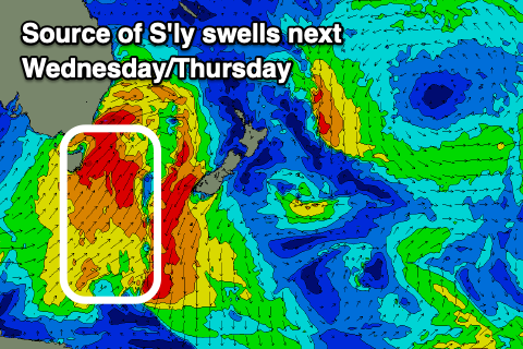
A stronger polar frontal system looks to produce a fetch of strong to gale-force S/SW winds right up past us, with a mix of mid-period energy due to build through the day.
At this stage we should see south facing beaches reaching 6ft into the afternoon but with strong SW winds, easing into the afternoon.
Thursday looks better with a light W-W/SW offshore before shifting S’ly into the afternoon and with easing 4-5ft+ sets, mixed in with some smaller S’ly groundswell.
Further pulses of S-S/SE swell with improving winds are due to follow into the end of the week/weekend but we’ll look at this more closely Monday. Have a great weekend!

