Good swells from the north-east to south-east
Eastern Tasmania Surf Forecast by Craig Brokensha (issued Monday March 11th)
Best Days: Wednesday morning, Thursday, Saturday, Sunday
Features of the Forecast (tl;dr)
- Small N/NE windswell tomorrow with early N/NW tending strong S/SE winds
- Weak S windswell for the PM, easing Wed
- Inconsistent E/NE trade-swell building Wed, easing slowly Thu PM
- Variable tending NE winds Wed, S/SW tending strong S/SE Thu
- Weak S swell Fri with SW tending S/SE winds
- Moderate sized, S/SE groundswell building Sat, peaking overnight, easing Sun
- W/SW tending NE winds Sat, N/NW tending NE Sun
Recap
Small, windswelly waves on Saturday stronger yesterday with workable morning winds, smaller again today.

Chunky sets yesterday AM
This week and weekend (Mar 12 - 17)
We should see small levels of N/NE windswell persisting into tomorrow morning, pulsing to 2ft+ from a final burst of N/NE winds down the coast overnight ahead of a strong S/SE change by mid-morning. With the timing, aim for a surf in southern corners for the best waves.
A weak, short-lived S'ly windswell will be generated by this change, easing Wednesday with nothing of note left in the tank.
We then look to the Coral Sea, where a broad fetch of strong E'ly trade-winds have generated a large trade-swell for the Gold Coast and northern NSW, moderate in size for southern NSW and smaller for us.
We can expect inconsistent levels of E/NE swell to start arriving through Wednesday building to a slow 2-3ft, holding Thursday morning and then easing later.
Variable offshore winds should create clean conditions Wednesday morning ahead of sea breezes, S/SW tending strong S/SE winds into Thursday, favouring southern corners again.
This second change will generate some better, mid-period S'ly swell for Friday, kicking to 3ft across south facing beaches but with average, fresh SW tending S/SE winds.

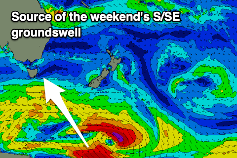
The weekend looks much better as winds ease and tend light W/SW along with some strong S/SE groundswell.
This will be generated by a good fetch of SE gales sitting south of New Zealand, on the polar shelf on Wednesday,
The fetch is quite board and as a result the swell should come in at a good 4-5ft Saturday afternoon, easing back Sunday from a similar size with morning NW winds. Afternoon sea breezes are likely both days so surf in the mornings.
Following this smaller, fun pulses of swell are on the cards, but more on this Wednesday.

