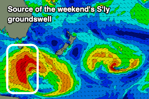
Great mix of swells for the coming period
Eastern Tasmania Surf Forecast by Craig Brokensha (issued Wednesday February 7)
Best Days: Tomorrow, Friday morning, protected spots Saturday for the keen, Sunday, Wednesday morning
Features of the Forecast (tl;dr)
- Moderate sized S/SE groundswell filling in tomorrow, peaking overnight and easing slowly Fri
- W/NW tending strong N/NE tomorrow
- W/NW tending E/SE winds Fri, then strong S/SE late
- Moderate + sized S'ly groundswell filling in Sat, peaking into the PM, easing Sun
- Gusty S/SW tending S/SE-SE winds Sat, NW tending N/NE Sun
- N/NE windswell for Mon, stronger Tue with strong N/NE winds
- Easing N/NE windswell Wed with SW winds
Recap
Fun levels of NE windswell yesterday across the coast, smaller and fading today.
This week and weekend (Feb 8 - 11)
The coming days look good regarding a fresh pulse of S/SE groundswell across the exposed beaches, generated on the southern flank of a strong polar low. A fetch of gale to severe-gale S/SE winds should produce a good kick in size tomorrow, building to 4ft across the magnets and easing from 4ft+ Friday morning.
Conditions tomorrow look favourable in the morning with a W/NW offshore, strengthening from the N/NE into the afternoon, favouring northern corners, while Friday morning will be great again with a W/NW offshore ahead of a shallow E/SE change, stronger S/SE into the evening.

This change is linked to a strong polar low firing up to our south-west tomorrow, pushing under the state Friday.
The catalyst for the low will be the remnants of a tropical low in the Indian Ocean, drifting south-east into the westerly storm track, deepening significantly south-west of us.
A fetch of severe-gale to storm-force W/SW-SW winds will be generated through our south-western swell window tomorrow, pushing further east and through our southern swell window Friday.
The latter stages will be best for the East Coast, with the groundswell from this source arriving through Saturday morning, peaking into the afternoon. South magnets should build to 4-5ft+ but with average, S/SW tending S/SE-SE winds, cleaner Sunday and out of the NW with easing sets from 4ft+.
In the wake of the low, a high will quickly slide in, followed by another trough in the Bight. This will bring strengthening N/NE-NE winds and building levels of NE windswell Monday but more so Tuesday with an offshore change for Wednesday. We'll have a closer look at this

