Make the most of tomorrow
Eastern Tasmania Surf Forecast by Craig Brokensha (issued Monday October 11)
Best Days: Tomorrow and Wednesday morning south magnets
Features of the Forecast (tl;dr)
- Moderate sized S'ly groundswell tomorrow with W tending N/NE winds
- Fading S swell Wed with NW tending gusty NE winds
- Easing, weak NE windswell Thu with strengthening N/NW-NW winds
Recap
A fading N/NE windswell with nothing of note over the weekend.
This week and weekend (Oct 12 - 17)

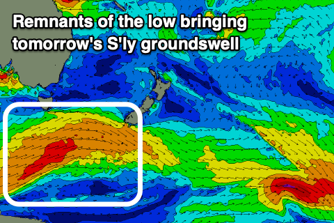
The coming forecast period revolves mostly around tomorrow's S'ly groundswell.
The source of this swell was a strong, zonal low on the polar shelf, generating a fetch of severe-gale W/NW-W winds fairly favourably through our southern swell window. A few storm-force barbs were also registered, with radial spread expected to see good sized sets arriving on the regional south swell magnets tomorrow to 4-5ft, much smaller at other breaks and inside southern corners.
Local winds look favourable with a light offshore due to give into N/NE sea breezes, favouring these magnets.
The swell will ease steadily into Wednesday back from 2-3ft max across the south magnets, tiny into the afternoon. Conditions will be clean with a NW offshore ahead of strong NE sea breezes and a late increase in NE windswell.
The infeed of NE winds looks a little disjointed so don't expect any major size with a weak 2ft wave due Thursday morning under strengthening N/NW-NW winds.
Longer term there's nothing too significant on the cards so make the most of the coming S'ly groundswell.

