Small weak swells ahead of strong surf next week
Eastern Tasmanian Surf Forecast by Craig Brokensha (issued Wednesday February 8th)
Best Days: Monday morning, Tuesday morning, Wednesday morning, Thursday morning
Features of the Forecast (tl;dr)
- Easing S swell tomorrow with light N tending fresh NE winds
- Small NE windswell tomorrow and Sat with variable tending SE winds Fri, S/SW tending SE winds Sat
- Possible late pulse of E/NE swell Sun, but building strongly Mon, peaking into the evening, easing slowly Tue
- W tending strong S/SE winds Sun, fresh S/SW tending strong S/SE-SE on Tue
- Light W tending NE winds Tue with variable tending NE winds Wed
- Reinforcing E/NE swell for Wed AM, easing into the PM and smaller Thu
Recap
Not much in the way of swell with a small south signal but with less than ideal winds.
This week and weekend (Feb 9 - 12)
The current small signal of south swell will ease back through tomorrow and winds should be a touch more favourable for the south magnets. Variable N breezes and fading 2ft sets from the magnets is expected, with Friday seeing a weak 1-2ft of NE windswell thanks to a quick burst of NE winds off the coast.
Variable winds are due to shift S/SE-SE on Friday afternoon/evening, opening up a couple of options for the keen in southern corners.
Any windswell seen through Friday will fade Saturday from 1-2ft with S/SW tending SE winds.
Now, of greater importance is the tropical developments currently underway in the Coral Sea.
A tropical low has been deepening while tracking south-west towards Queensland, with it recently forming into a Tropical Cyclone named Gabrielle.
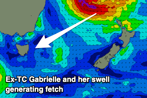
Gabrielle is forecast to reach Category 3 strength while making a track back to the south-east over the coming days, moving into our swell window Friday evening.

TC Gabrielle is expected to make an extra-tropical transition through Friday evening, resulting in an expansion of gale to severe-gales around its southern flank as it continues drifting south-east towards New Zealand.
This will be aimed through our eastern swell window, resulting in a moderate sized +, long-period E/NE groundswell for us on Monday.
We may see some small foreruners arriving through Sunday afternoon/evening but the bulk of the energy is due to build Monday, reaching 4-5ft+ across exposed coasts into the afternoon, easing from a similar size Tuesday morning.
The slow movement of the low once it moves across New Zealand will see strong to gale-force E/SE winds continued to be aimed through our eastern swell window, though off axis a little, during Sunday and Monday.
This should prolong the swell event, with the size due to hold 3-5ft through Wednesday morning before easing from 2ft+ Thursday.
Looking at the local winds and a morning W'ly is due Sunday ahead of a trough and strong S/SE change into the afternoon/evening. Monday when the bulk of the swell builds will see fresh S/SW tending SE, then E winds, with the morning being cleanest. Light morning offshores look likely Tuesday morning ahead of NE sea breezes, variable tending NE on Wednesday.
We'll have a closer look at the wind outlook on Friday though.

