Make the most of today
Eastern Tasmanian Surf Forecast by Craig Brokensha (issued Friday February 3rd)
Best Days: This afternon and evening, tomorrow morning for the keen
Features of the Forecast (tl;dr)
- Easing inconsistent E/NE swell with fresh N/NW winds, tending variable ahead of a late PM SW tending W/SW change
- Tiny S swell for Sun/Mon
- Small S swell for Wed with S/SW tending S/SE winds
Recap
A junky, building NE windswell through yesterday, with some better mid-period E/NE swell peaking today to a fun 2-3ft across the magnets with all day offshore winds.

Fun sets this afternoon
This weekend and next week (Feb 4 - 10)
Looking at the weekend ahead and today's fun peaky waves will fade with the source of E/NE winds generated west of New Zealand's North Island moving south out of our swell window during Wednesday.
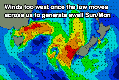
This will see easing 2ft sets (inconsistent) with gusty N/NW winds, tending variable ahead of a late SW-W/SW change.

The change will be linked to a strong polar low moving across us, but unfortunately by the time it moves into our swell window there'll be no strength between SW winds blowing out to sea and to the east.
We've got a sightly better swell generator for mid-week, but in all respects, the polar front linked to it looks a touch zonal and weak to generate any major size.
This front will clip us Tuesday with a small mid-period S'ly swell possibly showing on the south magnets to 2ft but with unfavourable S/SW tending S/SE winds.
Unfortunately following this there's not much to work with swell wise so try and make the most of the current energy. Have a great weekend!

