Make the most of the current swell
Eastern Tasmanian Surf Forecast by Craig Brokensha (issued Monday December 13th)
Best Days: Tomorrow, early Wednesday, Saturday morning for the keen
Features of the Forecast (tl;dr)
- Easing E'ly swell with N/NW tending S/SE winds tomorrow, easing further Wed with NW tending N/NE winds ahead of a late, stronger S/SE change
- Poor, weak S windswell Thu with S winds
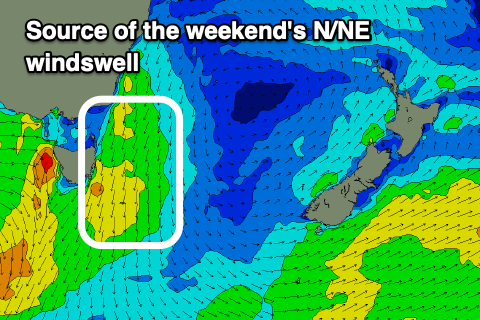
- Building N/NE windswell Sat with strengthening N/NE winds, easing Sun with W winds
Recap
Average building surf out of the S/SE and E on Saturday with a larger E'ly swell pushing in yesterday with weaker, workable onshore winds.
This morning was the pick with light winds and cleaner conditions before N/NE sea breezes kicked in. There are still quality options across northern corners.
This week and weekend (Dec 14 - 19)
The strong, stalling low linked to our current E'ly swell has since weakened considerably but it is still aiming a weak fetch of E/SE winds in our swell window. This will totally break down this evening with the swell due to ease in size and period through tomorrow.
Open beaches should still be a good 4ft or so, fading from 2ft on the sets Wednesday.
 Winds look favourable with a light to moderate N/NW offshore ahead of a shallow S/SE change moving up the coast through the day but petering out before really impacting the north.
This will then see NW winds kick back in Wednesday ahead of N/NE sea breezes and then a stronger, late S'ly change.
This change isn't due to bring much in the way of new swell, with some weak, small S'ly windswell due Thursday, fading Friday.
Into the weekend an approaching front will squeeze a high in the Tasman Sea, bringing strengthening N/NE winds and a building windswell to 3ft range later Saturday but with those average winds.
A change should be seen Saturday evening but the swell easing from a small 2ft max on the north-east magnets early Sunday. Following this the outlook is slow so make the most of the current energy!

