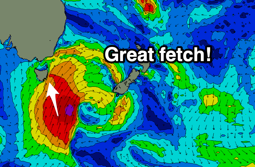
Large S'ly swells for the weekend
Eastern Tasmania Surf Forecast by Craig Brokensha (issued Friday 5th March)
Best Days: Selected locations tomorrow (protected into the PM), Sunday, Monday morning
Features of the Forecast (tl;dr)
- Large S'ly swell tomorrow with SW-W/SW tending fresh SE winds, easing Sun out of the S/SE with W/NW tending fresh N/NE winds
- Smaller easing swell Mon with SW tending E/NE winds
Recap
Small surf yesterday but today we've got our new building S'ly swell with 2-3ft sets in protected spots this morning, bigger on the south magnets. We should see sets hitting 4-6ft later today but with less favourable winds.
This week and weekend (Mar 6 - 12)
The large swell that's due across the coast later today has and is still being generated by an elongated polar front projecting up and across us. This system is now pushing up into the Tasman Sea though a fetch of S/SW gales are still being generated in our southern swell window.
 This will generate the best pulse of S'ly groundswell for tomorrow with 6ft+ surf due across exposed south facing beaches morning, with 8ft sets likely at deep water reefs and swell magnets.
The front will weaken slowly while continuing to project north-northeast into the Tasman Sea this evening, prolonging the swell event into Sunday.
The south magnets should still see 4-6ft sets in the morning, from a S/SE direction, easing steadily through the day and back from 3ft on Monday morning.
Come Tuesday the swell looks tiny and there's not much to follow for the rest of the week at this stage.
Winds tomorrow morning will be generally out of the SW, tending W/SW in pockets, though swinging fresh SE into the afternoon. Sunday looks great for the south magnets with a W/NW tending N/NE breeze. Monday looks to see light SW winds ahead of sea breezes.
Longer term, besides a small NE windswell mid-week there's nothing major on the cards, so make the most of the current coming swell. Have a great weekend!

