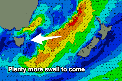
Good from the ENE and then large from the SSE
Eastern Tasmania Surf Forecast by Craig Brokensha (issued Monday 17th August)
Best Days: Every day this period, protected spots on the weekend
Recap
The surf built through the weekend, becoming large and stormy through yesterday, best in protected spots for experienced surfers.
Today winds swung more offshore along with large, easing levels of E/SE swell that was still pushing in at 4-6ft this afternoon.
This week and weekend (Aug 18 - 23)
The swell easing through today was generated by a great fetch of gales on the southern flank of a strong low dipping south through the Tasman Sea.
This has since weakened and moved out of our swell window, but a strengthening infeed of NE winds on the eastern flank of the low yesterday has generated a good reinforcing E/NE groundswell for tomorrow, building through the afternoon and then easing slowly Wednesday.
 Size wise we should see the swell magnets kick back to 4-6ft into the afternoon, easing from a similar size on Wednesday and then dropping more noticeably on Thursday from 3ft+.
We've also got a small S/SE swell on the cards for later Thursday and Friday morning, produced by a fetch of strong E/SE winds moving slowly away from us over the coming days.
This should produce a fun 2-3ft or so of S/SE swell as the E/NE swell eases.
Coming back to the local winds and W/NW tending NW breezes are due tomorrow N/NW all day Wednesday and then W/SW tending NW on Thursday. As the S/SE swell eases Friday strong W/NW winds will favour northern corners.
Now, moving into the weekend we'll see a deepening low pressure system moving in from the west and projecting a fetch of strong to gale-force SE winds up and into us Saturday, generating a large, stormy increase in S/SE swell for the weekend. Winds look poor Saturday but OK for protected locations Sunday. We'll have a closer look at this Wednesday though and make the most of the current swells!

