Slow days ahead of another extended run of easterly swell
Eastern Tasmania Surf Forecast by Craig Brokensha (issued Wednesday 12th August)
Best Days: Tomorrow morning for the desperate, possibly late Sunday, Monday through next week
Recap
Reinforcing pulses of fun E/NE swell to 2-3ft yesterday and today, but this swell is now likely on the way out.
This week and weekend (Aug 13 - 16)
The low pressure system linked to our fun run of E/NE swell has left the swell window and with this we'll see the swell easing this afternoon, dropping back further from 1-2ft on the magnets tomorrow morning.
Conditions will be great with a light offshore W/SW wind ahead of NE sea breezes.
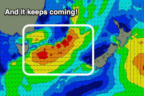
 We then look to another broad and deepening low that's forecast to form in the southern Tasman Sea over the weekend, aimed directly at us and for an extended period.
On Friday an initial trough will generate a weak fetch of E/NE winds through our swell window, kicking up a small increase in E'ly swell Saturday to 2ft to possibly 3ft but increasing E'ly onshore winds.
Sunday then looks stormy as the low starts to develop and strong onshore E winds are projected into us (gale-force out to sea). This will also kick up a rapid increase in size with 8-10ft waves due to develop into the afternoon.
Here's the bonus though, the low centre is expected to drift south, bringing an offshore SW change, likely overnight but come Monday we'll see fresh W/NW winds and a large easing E'ly groundswell from 6-8ft or so.
While the low will dip south, an infeed of strong E/NE winds are due to develop north-west of New Zealand's North Island, keeping the swell going well into the end of the week.
The pulse from this source looks to arrive Wednesday/Thursday and provide 4-6ft waves with offshore winds, but more on this Friday.

