Easing south to south-east energy, mix of swells next week
Eastern Tasmania Surf Forecast by Craig Brokensha (issued Wednesday 5th August)
Best Days: Protected spots tomorrow, early Friday, Saturday morning south swell magnets, Monday and Tuesday
Recap
An inconsistent pulse of new E/NE swell to 2-3ft+ across the region yesterday, replaced today by an oversized and stormy S/SE swell with gusty S'ly winds, opening up plenty of options in southern corners and novelty breaks.
This week and weekend (Aug 6 - 9)
 The strong and cold low responsible for today's oversized kick in S/SE swell is currently starting to slowly move north-east and with this, the swell producing fetch is swinging more southerly and away from our swell window.
With this we'll see a rapid drop in size and energy through tomorrow, down from 6ft to possibly 8ft across south swell magnets, much smaller in more protected breaks.
Friday then looks smaller and easing from 2-3ft.
Winds tomorrow will still be an issue with a fresh SW'ly across the northern half of the coast, more S/SW and stronger to the south with less swell. The afternoon will then see strong S'ly winds. Friday should see a morning W/SW-SW breeze, quickly shifting S/SE mid-late morning.
Come the weekend there's not expected to be much southerly energy left in the tank. A small 2ft wave may be seen Saturday, tiny Sunday.
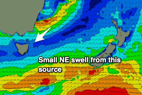
 Moving into Monday though a pulse of NE swell and S'ly groundswell are expected on the coast. The NE swell will be generated by a deepening low off the southern NSW coast, aiming a fetch of strong E'ly winds just on the edge of our swell window.
Size from this source looks limited and maybe 2-3ft across the north-east swell magnets, easing Tuesday.
The S'ly groundswell will be generated by a strong polar low forming under us on the weekend, producing a burst of severe-gale to storm-force W/SW-SW winds just within our swell window. This swell looks stronger and bigger with sets to 3-4ft across the south swell magnets. Winds however look SW to SE, favouring southern corners.
Longer term there are a few follow up pulses of S'ly swell on the cards and maybe a N/NE windswell, but more on this Friday.

