Great weekend out of the wind, S'ly swells next week
Eastern Tasmania Forecast by Craig Brokensha (issued Friday 17th July)
Best Days: Saturday, Sunday, Monday morning, Tuesday, Wednesday morning south magnets
Recap
Great waves the last couple of days with the stronger E’ly groundswell filling in with favourable winds.
This afternoon our final pulse of E’ly groundswell should have filled in, kicking back to 6ft+ across the coast and this will slowly ease through the weekend.
This weekend and next week (Jul 18 - 24)
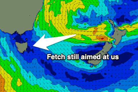
A projection of E’ly gales towards us this week from Cook Strait and New Zealand’s North Island should have produced a fresh pulse of strong E’ly groundswell this afternoon.
 This will start to ease through the weekend but the trend will be slow, as we’re still even today seeing a great fetch of strong E/SE winds in a similar position and weaker SE winds off the South Island.
Early tomorrow, 5-6ft+ sets are more than likely on the swell magnets, dropping through the afternoon and then back to 4-5ft Sunday morning ahead of a more noticeable easing trend.
Monday should still see small waves, but dropping from 2ft to possibly 3ft.
.png) Looking at the winds and strengthening N/NW breezes will favour northern corners all weekend, swinging strong W/SW-SW on Sunday as a cold front pushes up and across the state.
Looking at the winds and strengthening N/NW breezes will favour northern corners all weekend, swinging strong W/SW-SW on Sunday as a cold front pushes up and across the state.
This system has been upgraded since Wednesday and now looks to bring a good S’ly swell event that will build late Monday and peak Tuesday to 3-5ft across south facing beaches. Winds look to improve through the day as well Tuesday, swinging from SW to W into the afternoon.
Wednesday and Thursday morning will be smaller but we may see another strengthening polar frontal progression in our swell window mid-late week. This would deliver some new S’ly swell later week, but more on this Monday. Have a great weekend!

