Large run of easterly swell for the coming days

Eastern Tasmania Surf Forecast by Craig Brokensha (issued Monday 15th July)
Best Days: Every day this period
Recap
Small and clean to start yesterday but building through the afternoon and stronger and better into this morning with sets to 4-5ft. We should be seeing a larger pulse of E'ly groundswell hitting 6-8ft this afternoon but with S/SE winds.
This week and weekend (Jul 16 – 19)
These notes will be short a Ben's on annual leave.
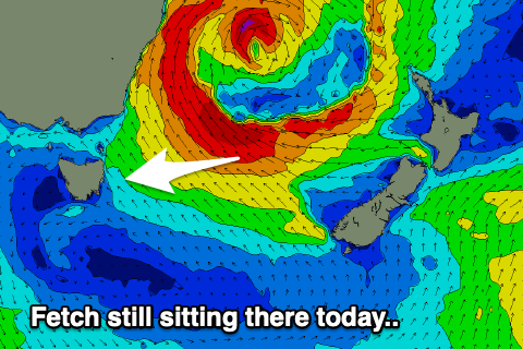 The larger pulse of E'ly groundswell due later today will hold tomorrow, generated on the southern flank of the 'bombing low' as it moved south and sat east of us today.
With a fetch of stationary E/SE gales now weakening a touch we'll ee open beaches persisting at 6ft to occasionally 8ft, while a re-intensification of E'ly gales out of Cook Strait looks to generate a reinforcing E'ly groundswell for later Friday and Saturday morning.
Size wise we probably won't see the surf dropping below 4-5ft Friday morning but then kicking back to 6ft+ with the new energy, easing Saturday from 5-6ft+.
From Sunday a more pronounced easing trend is expected owing to the low finally breaking down on the weekend, with dropping surf from 4-5ft, down to 2ft to possibly 3ft Monday.
Looking at the local winds and a morning SW'ly should swing S/SE through tomorrow afternoon and then W/SW tending NE on Friday. Come the weekend winds will start to strengthen, NW tending N/NW on Saturday and persistent N/NW all day Sunday. A change will then see W/SW winds on Monday.
Longer term we may see some small S'ly swell next week, but more on this Friday.