Slow ahead of exciting developments next week
Eastern Tasmania Surf Forecast by Craig Brokensha (issued Wednesday 8th July)
Best Days: South swell magnets tomorrow AM and possibly Saturday AM
Recap
A good mix of S'ly swells yesterday with clean conditions through the morning, easing back today from 2-3ft.
This week and weekend (Jul 9 - 12)
Our current S'ly swell will continue to ease tomorrow with possibly small 1-2ft leftovers on the south magnets along with NW winds.
The surf is then due to become tiny Friday through Saturday, besides a possible small hint of S'ly groundswell on the latter, generated by a polar fetch of W'ly gales today and tomorrow. This only looks to offer infrequent 1-2ft sets max.
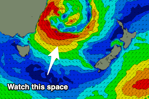
 We then look to the developments in the Tasman Sea through next week.
As talked about in this article here, we'll see an upper cold pool moving in slowly across the south-east of the country on the weekend, feeding a surface trough that will push off the southern NSW coast.
This is expected to result in the formation of a deep and powerful low pressure system, though the models diverge on the positioning at this early stage.
What we'll likely see is the low form off the southern NSW coast with a fetch of gale-force E-SE winds feeding into its southern flank, broadening through mid-next week as the low slowly expands.
Under this scenario building levels of large E'ly swell are due with onshore winds initially, cleaning up as the swell starts to ease late week. Check back over the coming week for updates on this dynamic and exciting storm.

